
 Latest News
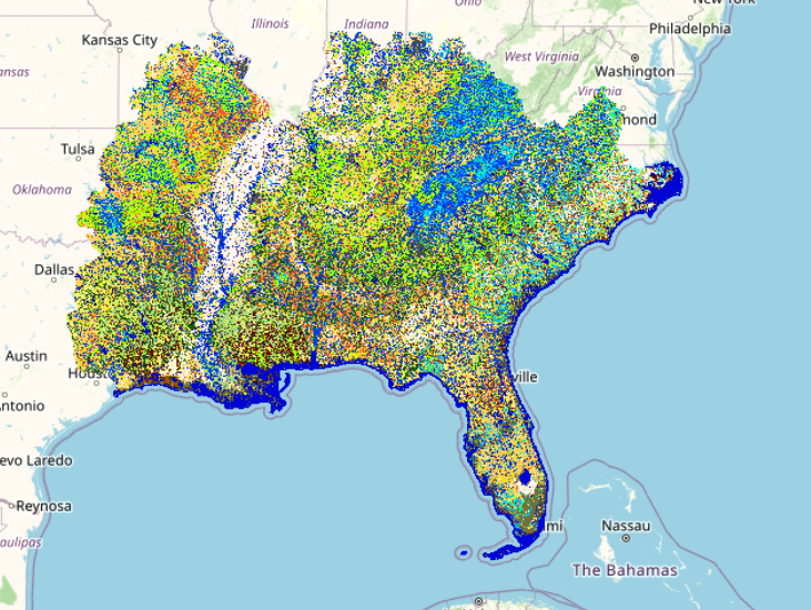
In the Southeast U.S. and other humid summer regions Daily MoD-FIS systematically adjusts surface fuel models (Scott and Burgan 2005) based on daily soil moisture values determined by the Keetch-Byram Drought Index (KBDI, Res. Paper SE-38). The KBDI is a soil moisture deficiency index developed to characterize the impacts of drought on the flammability of surface fuel to better reflect increased fire suppression difficulties under unusually dry conditions.
The Daily MoD-FIS products are generated automatically every evening in the LANDFIRE Map Viewer during a date range when the daily temperatures, on average, reach above the minimum temperature threshold that can support wildland fire, regardless of drought condition.
Concepts initially developed in the 1988 revisions of the National Fire Danger Rating System (NFDRS) and updated in the NFDRS 2016 version to address severe drought in the Southeast U.S. (NFDRS | NWCG) inform the ruleset used to build these daily maps. Fuel bed characteristics for each NFDRS fuel model along with suggested fuel load additions based on severe drought conditions inform the adjustments. KBDI values (www.wfas.net) are used to proportion the additional available fuel loading into four drought increments or classes that are defined by drought severity (none, low, moderate, high). Formulas that calculate fuel weight in proportion to the fuel time-lag size classes for each fuel load addition and account for fuel bed depth (which increases along with fuel weight) are used to maintain the packing ratio of the fuel model.
To help identify the day-of-year in the map file name, here is a Day-of-Year Calendar.
LF Product Used: LF Fire Behavior Fuel Model 40 (FBFM40)
Resources:
LANDFIRE MoD-FIS Drought Based Fuel Dynamic (DBFD) system 
MoD-FIS Poster presented at Missoula Fire Conference
MoD-FIS Comprehensive Plan
Scott and Burgan 2005: Standard Fire Behavior Fuel Models: A Comprehensive Set for Use with Rothermel's Surface Fire Spread Model
References:
Keetch, John J., and Byram, George. 1968. A drought index for forest fire control. Research Paper SE-38. Asheville, NC: U.S. Department of Agriculture, Forest Service, Southeastern Forest Experiment Station. 32 pp.