 |  |
Frequently Asked Questions (FAQs)
General
Q: How is The Nature Conservancy (TNC) involved in LANDFIRE?
Q: What is the connection between LANDFIRE and Landsat satellite imagery?
The Landsat program produces imagery that is the foundation for LANDFIRE's vegetation and disturbance data layers. The development of detailed vegetation maps are an essential component of LANDFIRE.
Q: How do I cite LANDFIRE data products?
| What do you want to cite? | Model | Example |
| General information from www.landfire.gov |
Homepage title. (Last update). [Homepage of], [Online]. Available: URL [Access date]. |
LANDFIRE. (2013, January - last update). [Homepage of the LANDFIRE Project, U.S. Department of Agriculture, Forest Service; U.S. Department of Interior], [Online]. Available: http://www.landfire.gov/index.php [2013, February 8]. |
| LANDFIRE spatial data products | Homepage title: Data product. (Last update). Agency. [Online]. Available: URL [Access date]. | LANDFIRE: LANDFIRE Existing Vegetation Type layer. (2013, June - last update). U.S. Department of Interior, Geological Survey, and U.S. Department of Agriculture. [Online]. Available: http://landfire.cr.usgs.gov/viewer/ [2013,May 8]. |
| LANDFIRE non-spatial data products | Homepage title: Data Product. (Last update). [Homepage of], [Online]. Available: URL [Access date]. | LANDFIRE: LANDFIRE Vegetation Dynamics Models. (2013, June - last update). [Homepage of the LANDFIRE Project, U.S. Department of Agriculture, Forest Service; U.S. Department of Interior], [Online]. Available: http://www.landfire.gov/index.php [2013, May 8]. |
Q: At what scale should LANDFIRE data be used?
LANDFIRE products were designed to support national, regional, and sub-regional analysis activities.
Considerations:
- The native spatial resolution of LANDFIRE raster spatial products is 30-meters, however, the appropriate application scale is much larger than 30 meters, and will vary by a combination of product, location, and specific use.
- Users should refer to the metadata and local, regional or expert knowledge to determine if LANDFIRE products are appropriate for their application in their area.
- LANDFIRE products are not intended to replace local products, but serve as a rich supplemental data source with complete areal coverage, regardless of ownership.
Q: What map projection do I need to do a fire analysis?
Our suggestion is to consider your intended use. LF native projection, USA Contiguous Albers Equal Area Conic (NAD_1983_CONUS_Albers or NAD_1983_Alaska_Albers), is perfect for larger area analysis, such as multiple states, etc. However, when doing any other types of analysis, such as local analysis, one may need to adapt LF products. If you are using software applications like FlamMap or FARSITE, it is best to reproject the products and use a north up projection, such as Best-FIT UTM (NAD83). If data are not reprojected to a north up projection, models could produce unexpected results. It's good practice to understand the map projection characteristics of the products and, when necessary, reproject them to best fit your needs. LF viewer download options allow you to choose NAD 1983 Albers (Standard Projection) or Best-Fit UTM (NAD83 Datum).
Q: LANDFIRE data are in what projection?
CONUS
Projection type: USA Contiguous Albers Equal Area Conic (referenced as NAD_1983_CONUS_Albers (EPSG:5070))
Spheroid name: GRS 1980
Datum name: NAD83
Latitude of 1st parallel: 29.50 N
Latitude of 2nd parallel: 45.50 N
Longitude of central meridian: -96.00 W
Latitude of origin of projection: 23.00 N
False easting at central meridian: 0.0 meters
False northing at origin: 0.0 meters
Alaska
Projection type: Alaska Albers Equal Area (referenced as NAD_1983_Alaska_Albers (EPSG:3338))
Spheroid name: GRS 1980
Datum name: NAD83
Latitude of 1st parallel: 55.000 N
Latitude of 2nd parallel: 65.00 N
Longitude of central meridian: -154.00 W
Latitude of origin of projection: 50.00 N
False easting at central meridian: 0.0 meters
False northing at origin: 0.0 meters
Hawaii
Projection type: Albers Equal Area (referenced as Hawaii_Albers_Equal_Area_Conic (ESRI:102007))
Spheroid name: GRS 1980
Datum name: NAD83
Latitude of 1st parallel: 8.00 N
Latitude of 2nd parallel: 18.00 N
Longitude of central meridian: -157.00 W
Latitude of origin of projection: 13.00 N
False easting at central meridian: 0.0 meters
False northing at origin: 0.0 meters
Insular Areas (IA)
Projections are in best fit WGS 1984 UTM for Northern and Southern Hemispheres
Q: Why am I unable to view Hawaii data using Web Coverage Service (WCS)?
Hawaii is the only extent that the provided WCS URLs will only work with ESRI tools as the data is projected in ESRI 102007. QGIS and other non-ESRI products, will be unable to use the WCS URLs to view the Hawaii LF data.
Q: I have been working with the GAP/LANDFIRE National Terrestrial Ecosystems 2011 vegetation data set and I have a few questions about some of the non-natural vegetation categories. Is there a place where I can find information on the categories?
The U.S. Geological Survey Gap Analysis Project (GAP)/LANDFIRE National Terrestrial Ecosystems 2011 is maintained by GAP, not LANDFIRE. The information, resources, and contact information can be found on the GAP/LANDFIRE National Terrestrial Ecosystems 2011 web page at (https://www.sciencebase.gov/catalog/item/573cc51be4b0dae0d5e4b0c5 ).
Q: Are there a full LANDFIRE Mapzone Extent shapefiles available?
LF users can download the CONUS and Alaska Mapzone Extent shapefiles, which includes both the 90k and 0k shapefiles, from our LF library at: https://landfire.gov/library_list.php?cat=1, under Shapefiles.
A user can also search for "mapzone" on our library page, and the link will be provided to the mapzone location.
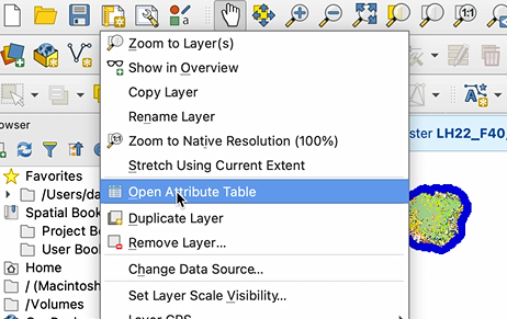
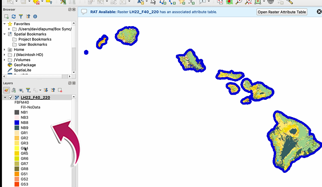
Q: How do I classify a raster using LF Data with QGIS?
- Install the Raster Attribute Table (RAT) plugin, install: https://plugins.qgis.org/plugins/RasterAttributeTable/
- Add the raster file to QGIS
- If a RAT exists you will see the RAT available bar, shown below
- If data was downloaded from LF Viewer or from the website page for Mosaic Downloads, the attribute table is included
- If data was downloaded from the LFPS tool, an attribute table can be found at LF library (CSV)
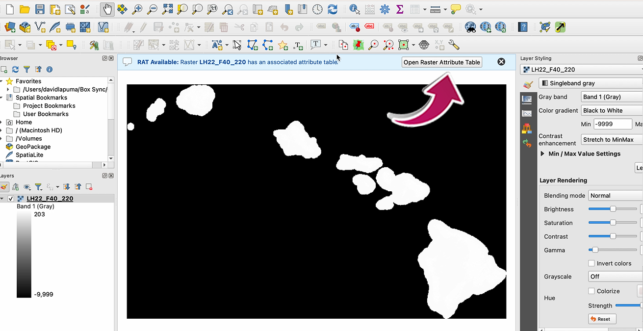
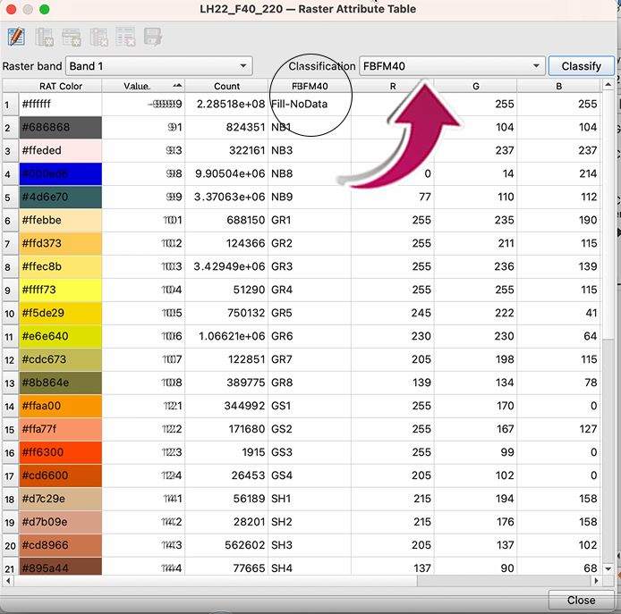
- A pop-up window will ask if you want to overwrite the existing classification--select YES
ArcGIS
Q: Why am I unable to select ArcGrid when downloading data in the new LF Viewer?
With the release of the new viewer, ArcGrid, LFDAT, and Non-ESRI scripting (data access ESRI tools and formats) were archived. LF is changing technology to move with the industry towards GeoTIFF. As a result, ArcGrid will no longer be supported as we move technologies to Open Geospatial Consortium (OGC) standards.
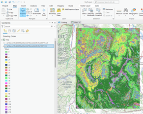
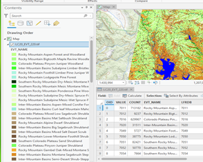
Q: Is there an easy way to utilize the color attribute fields of LF product raster attribute tables to map and apply this color symbology (RGB) to the raster in Arc?

A significant aspect of managing each map layer is the ability to set a wide array of layer properties in the Properties dialog box. To display as LANDFIRE displays on the viewer:
ArcMap:
- Right click the layer in ArcMap
- Click on Properties
- Click on Symbology
- Select Unique Values
- In Value Field use the dropdown to select the desired field
- To display your data in the same way that the map viewer does, select the "Name or Label" field
ArcPro:
- Right click on the layer in ArcPro and select Symbology
- A dialog box will open, under Primary Symbology select Unique Values from the dropdown list
- Below that box, you will see Field 1, use the dropdown to select the desired field for display
- To display your data in the same way that the map viewer does, select the "Name or Label" field
It may also be helpful to review the "Setting layer properties" on the ArcMap web page or ArcPro web Page prior to working with LANDFIRE products.
LFPS
Q: Can I join my attribute table to my multi-band GeoTIFF file I downloaded from LFPS?
LFPS produces multi-band GeoTIFFs which are multi-band floating-point raster datasets. Because raster attribute tables can only be built for single-band integer raster datasets, multi-band GeoTIFFs cannot have an attribute table joined. To remedy this, you can export individual bands from the LFPS output and join with an attribute table.
LF Attribute Tables are in the Comma Separated Value (CSV) format. To find the appropriate .csv file, go to the LANDFIRE Library, select the Comma Separated Value (CSV) link and search for the product .csv you need. Download the .csv file(s) and then follow the steps detailed in the instructions below:
Note: Since these are multi-band GeoTIFFs, drag-and-drop into ArcPro will not work. Users must use the recommended process of clicking on "Add Data" to bring their GeoTIFF into ArcPro.
ArcMap/ArcGIS Pro
- Click the Add Data dialog box (this is different for ArcMap vs ArcGIS Pro)
- Click on the file name of the LFPS GeoTIFF (make sure you expand the zip file first)
- Select and add the individual band(s) to which you want to join attributes
- Export each band as format TIFF
- In the Layer Properties menu, change the symbology in each band to Unique Values and select Yes to build a raster attribute table
- Join the attributes based on Value and the relevant attribute table (.csv) table
- Export the raster again to make the join permanent
As shown in the images below, the categorial information is missing from the multi-band GeoTIFF downloaded from LFPS, but after joining the attribute table to the individual exported raster, the attribute information is present.
 LFPS download legend prior to split of GeoTIFF bands |
 LFPS download legend after joining the attribute table |
Fire Regimes Data
Q: Is VCC the same as FRCC?
Vegetation Condition Class (VCC) and Vegetation Departure (VDep) are the same data that was previously called Fire Regime Condition Class (FRCC) and Fire Regime Departure Index (DEP). According to the FRCC Guidebook, FRCC was an interagency tool used to determine the degree of ecological departure from historical, or reference condition, vegetation, fuels, and disturbance regimes. FRCC, a combination of vegetation departure, fire frequency, and severity departure, were measures of vegetation departure, hence the name change.
Q: How are reference conditions generated?
Reference conditions for LF c2001 were generated using LANDSUM. Reference conditions for LF 2008 through LF 2014 were developed using the original version of the BpS models developed using the Vegetation Dynamics Development Tool (VDDT). Reference conditions for LF 2016 and later were based on results from ST-Sim BpS models reviewed and revised by local experts 2016 - 2019.
Q: What summary units are used in VCC?
Summary units for vegetation departure calculations varied across the LANDFIRE versions and are specified on the Vegetation Departure web page.
Q: Why did the layer name change from FRCC to VCC?
LANDFIRE (LF) never delivered "full" Fire Regime Condition Class (FRCC) even when the product carried that name, so it was renamed to reduce confusion.
FRCC is composed of two elements: Vegetation Departure and Fire Regime Departure. LF produced and delivered the first component of FRCC (Vegetation Departure) because LF had no consistent way to estimate Fire Regime Departure over the entire geography. Therefore, the product was renamed Vegetation Condition Class (VCC) since it is a more appropriate and descriptive name. VCC is Vegetation Departure sliced into categories.
Canopy Fuel
Q: Why do the forest canopy maps have values of zero in some places?
Q: In what units are LANDFIRE Canopy Base Height (CBH) and Canopy Bulk Density (CBD) measured?
Q: Why are there odd lines in the canopy fuel data?
Note that these lines exist in the Existing Vegetation Type layer as well. These lines result form radiometric oddities in the satellite imagery used to create these layers. This phenomenon generally occurs on the seam where two satellite overpasses from different dates were mosaicked to produce a seamless coverage of each zone. Since satellite imagery serves as a predictor of canopy base height (CBH) and canopy bulk density (CBD), the lines are "stamped" onto the resulting CBH and CBD layers.
Q: Why are all hardwood existing vegetation types coded with a canopy base height of 10 meters (raster value of 100 meters * 10)?
Q: How is canopy base height and canopy bulk density calculated in LANDFIRE?
Surface Fuel
Q: How are the LANDFIRE fire behavior fuel model maps created?
We create rule sets based on existing vegetation type, existing vegetation cover, existing vegetation height, and environmental site potential. We assign a fire behavior fuel model to each rule set and then engage local experts to review and calibrate the rules and resulting maps. Full descriptions of the LANDFIRE fire behavior fuel model products can be found in the Fuel Data Products Overview.
Q: How do rule changes affect neighboring zones?
Rules must be nationally consistent; therefore, if one rule for one existing vegetation type (EVT) is changed, then the change affects that EVT in all zones. However, some types behave distinctly differently due to local variation, and this information would be reflected in the resultant map. This type of local variability is determined through expert opinions garnered from LANDFIRE calibration workshops.
Q: Why aren't there slash models (FBFMs 11, 12, 13) in regions with abundant slash?
LF 2016 Remap
Q: What is different with Vegetation for LF Remap?
From a very high level there are minimal changes with Existing Vegetation Type (EVT). EVT for LF Remap uses Ecological Systems Classification System and was created using Landsat imagery, the LF LFRDB, as well as other geospatial inputs and classification trees. One of the more significant changes is with Existing Vegetation Height and Existing Vegetation Cover. Those products are now continuous data vs. binned into categories as before.
For LF Remap's Biophysical Settings, Mean Fire Return Interval, Percent of Low-severity Fire, Percent of Mixed-severity Fire, Percent of Replacement-severity Fire, and Fire Regime Groups are now attributes of this product.
A new product is the National Vegetation Classification which represents the current distribution of vegetation groups within the U.S. National Vegetation Classification circa 2016.
Q: What year does LF Remap represent?
LF Remap's comprehensive vegetation and fuels mapping reflects circa 2016 ground conditions. As part LF Remap, disturbances on the landscape were mapped for the years 2015 and 2016.
Q: What are the imagery dates for LF Remap?
LF Remap mapping efforts use 2013 - 2017 imagery. Priority was given to imagery from 2016.
LF Data Access Tool (LFDAT)
Q: With the release of the new LF Viewer, where did the LANDFIRE Data Access Tool (LFDAT) go?
LFDAT, ArcGRID, and Non-ESRI scripting (data access ESRI tools and formats) are being archived, starting April 2022.
If a user has the LFDAT client server tool on their system, users can continue using the tool; however, users will not be able to get new data and LANDFIRE will no longer support the tool.
Many of the LFDAT capabilities will be offered on LANDFIRE's new viewer (https://landfire.gov/viewer) and on the LANDFIRE Product Service (https://lfps.usgs.gov/arcgis/rest/services/LandfireProductService/GPServer).
The new viewer modernized the current map viewer to facilitate larger downloads, as well as:
- Refine the user interface to account for more versions of the product suite
- Migrate from ESRI to consistent interfaces using open-source solutions
- Improve data download/distribution tools to provide more capabilities to a diverse user community
- Replace LFDAT application capabilities with web-based services & tools
- Modernize data formats with increased capabilities
Data Streaming
Q: Was there a change in streaming LF data?
Yes. With the release of LF's new viewer in late March 2022, LF data access with ArcGRID, LFDAT, and Non-ESRI scripting was archived. Note Non-ESRI scripting was removed July 1, 2022. However, the LF Program developed a new method to access its products called the LF Product Service (LFPS). LFPS is a RESTful Application Programming Interface (API) that allows users to request and download a LF products file, an output file incorporating the requested product layers via a multiband raster, through an API using HTTPS requests. Features of the LFPS include:
- Resampling product layers to a coarser resolution, defining an output projection for a study area, and editing select product layers based on rules using other product layers within the products file
- 100% RESTful
- Supports GET & POST for Endpoints
- All Downloads Endpoint(s) support Cross-Origin Resource Sharing (CORS)
- Asynchronous by default
Q: How can I access the LANDFIRE Product Service (LFPS)?
The LFPS can be accessed in several ways:
- ESRI's REST API/Web Interface at https://lfps.usgs.gov/arcgis/rest/services/LandfireProductService/GPServer
- Python, php, unix wget, or anything that can call a URL (including an internet browser)
- Scripting tools like Postman (https://www.postman.com/)
Q: What are alternative options now that the map service is retired?
The LANDFIRE (LF) program has upgraded to use OGC Geoserver. With this change, map services using the call to https://landfire.cr.usgs.gov/arcgis/rest/services/Landfire/US_200/MapServer are no longer available.
How can a user get LF data in a similar manner?
WMS, WCS, and Image Service URLs are available at https://www.landfire.gov/data_access.php.
These calls will no longer contain the inclusion of the attribute table.
Note: The only way to include an attribute table is to download the data from the following::
- LF Map Viewer
- LANDIRE Product Service
- Download Mosaic Data Products
LF Total Fuel Change Tool (LFTFC)
Q: What do the LFTFC professionals do in areas that have multiple disturbances over the 10-year period, such as a harvest, then a pile treatment, and then a pile burn treatment in consecutive years?
The LF Program realizes there is time between when a mechanical remove disturbance happens and when the activity fuels from it are treated, but LF assumes that activity fuels are being treated shortly after. This is what LF uses for multiple entries, in this order:
- High severity fire. Has probably the most impact on the landscape
- High severity mechanical remove. We assume that most of the overstory is removed, site prep for planting takes place, and then planting
- All other fires ranging from moderate to low severity fires
- Whichever happened most recent of the remaining disturbances
- If only one disturbance occurred, then that is the one assigned
It would be ideal to be able to track every activity through its full progression, but there is not a good way for LF to do that for all the U.S. in a timely manner. In addition, private landowners typically do not report disturbance activities and some areas in the U.S. treat activity fuels differently, such as reducing the fuel bed depth and having high rates of decomposition to take care of them in a timely manner. It is easier when the LF team remotely detects disturbances to assume the activity fuels are being treated appropriately according to regulations.
Q: We are having a hard time working with the Master_CMB as a lookup due to the size. I know it's typical to work in ArcGIS when using the Master_CMB table, but was wondering if there are any tips or tricks we should know about when trying to query from that table?
LF breaks the table down into zones which makes it a little easier to deal with. In the LFTFC toolbar it makes the management unit GRID of the zone/area of interest then copies the attribute table to the database and that is the _cmb table for that area. The rulesets table assigns the fuels to the appropriate fields in the _cmb then the table is joined back to the GRID, where LFTFC does a lookup function on the fuel field the user is interested in, for a GRID product.
Reference Products
Q: What types of data are needed for LANDFIRE updates?
We need data that can be used to update LANDFIRE data layers, and data that could be used to remedy known concerns with previous versions. In a nutshell, we need Event data on any recent (current update cycle) disturbances or vegetation/fuel treatments that would have altered the composition or structure of vegetation and/or fuel. In addition to Event data, LANDFIRE also benefits from point or polygon vegetation or fuel plot data which may be incorporated in the LANDFIRE Reference Database (LFRDB).
Q: When do you need the data?
The annual data submission deadline is November 30 of each year. Please make every effort to submit your data by November 30 of each year, as LF is relying heavily on user contributed data for this update. Data submitted after the deadline will be used if schedules allow or be archived for future use. All data contributions must meet LF requirements.
Q: In what format do you need the data?
We will accept Event data (disturbance and vegetation/fuel treatment data) in various formats, including ESRI shapefiles, geodatabases, and ArcInfo coverages. Supporting information, including definitions of the fields and any codes in the data tables, should accompany the data to ensure that they can be interpreted correctly. If you have LFRDB data (vegetation and/or fuel plot data) to share, we're even more flexible in terms of data format. We'll gladly accept digital data in, text files, spreadsheets, relational databases, ESRI shapefiles or geodatabases, and ArcInfo coverages - whichever is most convenient for the contributor. Coordinate information, including map datum, can be bundled with the other attribute information or in a separate, linked file, or data form. Supporting information, including definitions of the fields and any codes in the data tables or data-entry forms, should accompany the data to ensure that they are accurately represented in the LANDFIRE reference database.
Q: What is the purpose of LANDFIRE updates?
An update program is vital to support the full spectrum of fire and natural resource management programs with timely and quality products that reflect recent changes in landscape conditions. The LANDFIRE updates focus on landscape changes to vegetation and fuels resulting from disturbance and treatment activities such as wildland fire, fuel and vegetation treatments, mortality from insects and disease, storm damage, invasive plants, and other natural or anthropogenic events. Areas of concern will be improved through the LANDFIRE update process, and the existing layers will be updated to reflect more current conditions.
Q: How do we submit data to LANDFIRE and who should we contact if we have questions?
If you have questions or would like to submit data please contact Brenda Lundberg, LANDFIRE Reference Data Administrator. You may email datasets smaller than 25MB to blundberg@contractor.usgs.gov. If the files are too large to send via email please contact Brenda Lundberg for alternative file transfer options.
Q: We have submitted similar information to a web-based data clearing house such as the NPS Data Store or an agency/corporate database system such as USFS-FACTS (Forest Service Activity Tracking System). Why don't you simply download the information you need from those existing websites or agency databases?
LANDFIRE does draw data from several web based data clearing houses including the NPS Data Store, USGS/NPS Vegetation Characterization Website, and USFS Regional Data Clearing houses. LANDFIRE also acquires data from agency/corporate database systems such as USFS FACTS (Forest Service Activity Tracking System) and USFS NRIS (Natural Resource Information System). The Website Agency DB Table provides a complete list of websites or agency database systems from which LANDFIRE draws data. For a copy of the Website Agency DB Table please visit http://www.landfire.gov/participate_refdata_sub.php. If you store data on one of the websites or agency databases listed in this table, please verify that a current version of your data are posted to ensure that this data will be evaluated for use in the next LANDFIRE update cycle.
Q: Is geolocation data available for individual trees within the Public LFRDB for LF 2016 Remap (LF Remap)? Are there UTM's for individual trees in the plots? Are data available for the shape and size of the individual plots?
LANDFIRE does not have distance or azimuth for any individual trees included in the Public LFRDB for LF Remap. LANDFIRE tracks these details internally, but LF only has 76 public plots that have distance and azimuth for individual trees, and these plots are located in the Great Dismal Swamp. Additionally, LF does not have data available for the size and shape of any of the plots.
Vegetation Data
Q: Why does LANDFIRE use VDDT?
Although other quantitative state-and-transition models exist, VDDT (Beukema and others 2003) was selected as the model of choice for nationally consistent fire and fuel projects because it is:
- public domain, free and accessible to all (www.essa.com/vddt)
- user-friendly
- non-spatial, not affected by lack of spatial data or data storage requirements
Beukema, S.J.; Kurz, W. A.; Pinkham, C.B.; Milosheva, K.; Frid, L. 2003. Vegetation Dynamics development tool, User.s Guide, Version 4.4c. Prepared by ESSA Technologies Ltd., Vancouver, BC. 239 p. [Online.] Available: www.essa.com/vddt.
Keane, R.E.; Parsons, R.; Hessburg, P. 2002. Estimating historical range and variation of landscape patch dynamics: limitations of the simulation approach. Ecological Modeling. 151: 29-49.
Q: What is VDDT?
Q: How is the accuracy of LANDFIRE vegetation data assessed?
- quantitative, site specific agreement assessment by map zone and groups of map zones using withheld field plots
- case studies in selected areas
Learn more about Data Product Quality.
Q: What if we have an existing regional classification that we like better?
Q: What are the satellite imagery dates for the existing vegetation products?
LANDFIRE National (LF c2001) existing vegetation products portray vegetation composition and structure conditions circa 2001. The time period is determined by the average date of Landsat satellite imagery acquisition used for the original mapping, which occurred from 2000 to 2002. Subsequent versions (LF 2001, LF 2008, LF 2010, LF 2012, and LF 2014) used National as a starting point for data processing. Disturbances mapped in updated versions beyond National used imagery from 1999-2014 where the imagery year corresponds to the disturbance year.
Q: What are the LANDFIRE design criteria for developing vegetation map units?
LANDFIRE vegetation map units must be:
Identifiable - Vegetation map units must be able to be keyed from the LANDFIRE reference database, which is a field-referenced database made up of a compilation of existing government and non-government inventory databases. Additionally, all map units must adhere to standard federal terminology used in vegetation map unit classifications and descriptions of vegetation map units.
Scalable - Vegetation map units must be hierarchical with regard to floristic and spatial scale. The aggregation and division of map units must be straightforward. The LANDFIRE map units must tier, where possible, to the physiognomic and floristic hierarchy detailed in the Federal Geographic Data Committee's (FGDC) Vegetation Classification Standard (FGDC 1997) and other documents describing national vegetation map unit classifications (Eyre 1980; Shiflet 1994; Grossman and others 1998; Comer and others 2003; Brohman and Bryant 2005).
Mappable - Vegetation map units must be capable of being accurately portrayed geospatially as discrete entities and as attributes in geospatial databases. Field-referenced data used to develop training databases must have adequate vegetation information to distinguish vegetation map units. These map units must be congruent with approaches that integrate Landsat-based remote sensing and machine-learning techniques with biophysical gradient modeling for mapping vegetation across broad areas.
Model-able - Vegetation map units must be logically consistent with the framework of the landscape fire succession models critical for simulating historical fire regimes and vegetation.
Brohman, R.; Bryant, L. eds.2005. Existing vegetation classification and mapping technical guide. Gen. Tech. Rep. WO-67. Washington, DC: U.S., Department of Agriculture Forest Service, Ecosystem Management Coordination Staff. 305 pp.
Comer, P., D. Faber-Langendoen, R. Evans, S. Gawler, C. Josse, G. Kittel, S. Menard, M. Pyne, M. Reid, K. Schulz, K. Snow, and J. Teague. 2003. Ecological Systems of the United States: A Working Classification of U.S. Terrestrial Systems. NatureServe, Arlington, VA. 75 p.
Eyre, F. H. E. 1980. Forest cover types of the United States and Canada. Society of American Foresters, Washington DC., USA.
FGDC, ed.[Online] http://www.fgdc.gov/standards/projects/FGDC-standards-projects/vegetation/vegclass.pdf/view?searchterm=vegclass.pdf
Grossman, D. H., D. Faber-Langendoen, A.S. Weakley, M. Anderson, P. Bourgeron, R. Crawford, K. Goodin, S. Landaal, K. Metzler, K. Patterson, M. Pyne, M. Reid, and L. Sneddon. 1998. International classification of ecological communities: Terrestrial vegetation of the United States Volume I. The National Vegetation Classification System: development, status, and applications. The Nature Conservancy, Arlington VA., USA.
Shiflet, T. N. E. 1994. Rangeland cover types of the United States. Denver, CO, USA: Society of Range Management. 151 p.
Q: Does the sensor problem with Landsat 7 affect LANDFIRE mapping?
LF Disturbance mapping used the following imagery to identify changes to the landscape post LF c2001:
| LANDSAT | Disturbance Year |
| 5 | 1999 - 2008 |
| 5 and 7 | 2009 - 2010 |
| 5 | 2011 |
| 7 | 2012 |
Landsat 7 SLC-off imagery were used for MTBS fire mapping and MTBS data was included in LF 2008, LF 2010, and LF 2012. Landsat 7 SLC-off imagery has scan line issues. For LF 2012, these issues were addressed, however, they were not corrected in LF 2008 and LF 2010.
To reduce the impact of the scan line artifacts in LF 2012 data products caused by gaps in MTBS data, a combination of modeling and image processing techniques were applied. Decision-tree modeling was implemented when appropriate image data were available. A majority focal filling raster image processing technique with a 12 x 12 filter was used when suitable imagery was unavailable. The disturbance legend was modified to account for the additional processing methods so users can identify the source for each disturbed pixel.
Q: Why is mapping existing vegetation necessary?
Q: What is potential vegetation (PV) and what time periods do the potential vegetation layers represent?
PV is the vegetation capable of existing given the biophysical characteristics of a site. PV integrates current regional climate and physical site characteristics.
LANDFIRE characterizes PV in two ways:
- Environmental Site Potential (ESP) is the vegetation that would become established at late or climax stages of successional development in the absence of disturbance (pre European). ESP reflects the dates of the input data used in the mapping process (approx. 1980-2004 for field data and 1980-1997 for biophysical gradient layers developed from DAYMET data). It also includes the competitive potential of native plant species. The ESP layer informs vegetation and fuel mapping.
- Biophysical Settings (BpS) is a refinement of ESP and incorporates natural ecological disturbance processes, such as fire. The biophysical settings (BpS) layer represents a composite time period that includes the "current" input data, the historical context provided by vegetation dynamics models, and assumptions about fire regimes. It forms the basis for linking ecological processes of succession to landscapes, which is used to simulate historical vegetation and disturbance characteristics.