

 Latest News
In 2004 the Summer Olympics were held in Greece, the Spirit Rover landed on Mars, the Boston Red Sox won the World Series, and an important new program emerged from the increased concern about the number, severity, and size of wildland fires: LANDFIRE.
Now, in 2019, our landmark 15th year, LF continues to fulfill its charter to produce nationally consistent and comprehensive biological, ecological, and geospatial products and databases across the United States and insular areas.
Over time, LF has evolved from a program focused mainly on wildfire into a dynamic collaboration that supports environmental compliance work across organization and landscape boundaries, whether applications are fire-related or not. Take a glimpse at the power, functionality, and impact of LANDFIRE’s suite of products, data, and tools during the last five years, starting with an award
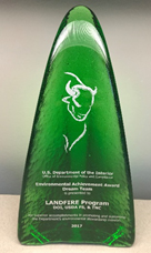
 Annually, the U.S. Department of the Interior (DOI) presents Environmental Achievement Awards that recognize employees, teams, and partners who have attained exceptional environmental achievements that go above and beyond the person's or team's regular, expected duties. In May 2018 it was announced that LANDFIRE received the Department's 2017 Environmental Dream Team award for being "environmental champions and agents of change who work across organizational boundaries to enhance environmental stewardship, create efficiencies, improve communication, avoid or address conflict at the lowest levels, or reduce environmental review times." To earn the distinction, LANDFIRE demonstrated that the program is unique in its approach; that it produces clear, repeatable results at national scale; and that those clear results improve DOI operations.
Besides continuing our best practices of listening to user feedback and delivering updated and new products, we began a remapping effort of the United States and Insular Areas to produce a new LF base product suite representing contemporary conditions and completed a Biophysical Settings review and update.
Just a few of the highlights:
The LANDFIRE 2014 Update, as with the 2010 and 2012 updates, was a vegetation and fuels mapping effort to update the LF National base product suite, incorporating landscape change and disturbances (wildland fire, fuel and vegetation treatments, insects and disease, storm damage, and invasive plants) that occurred in 2013 and 2014. It included responses to vegetation successional change in forested types and revisions to address discrepancies between map products and known field conditions.
Modeling Dynamic Fuels with an Index System (MoD-FIS) seasonal products is a strategy LF developed for mapping dynamic fuels by incorporating seasonal variability of herbaceous cover. MoD-FIS captures changes to fire behavior fuel models on current fire season herbaceous production. Two model-ready indexes of MoD-FIS are currently applied to account for fuel's seasonal variability representing up-to-date conditions so that analysts can access current-state data expressed through fuel availability in real-time to near real-time conditions.
LF 2016 Remap, a comprehensive effort to remap the entire U.S. and Insular Areas, provides a new base map product suite representing circa 2016 ground conditions. Designed to produce vegetation and fuels data that inform wildland fire and ecological decision systems, LF Remap products offer significant improvements to all previous LF versions. Five new products were added with LF Remap: Historical Disturbance, National Vegetation Classification, and Fuel Vegetation Cover, Height, and Type. A new capability that improves performance of fire behavior modeling was also added, "capable fuels." By synchronizing Time Since Disturbance, users may not need to do much, if any adjustments, to the vegetation and fuel attributes to represent contemporary conditions. LF Remap products are being released incrementally by GeoArea into 2021.
Biophysical Settings have been reviewed and updated. LF produced and delivered state-and-transition models for every ecosystem (Biophysical Settings, or BpS) mapped by the program during the first 10 years of the project, offering information about vegetation dynamics, structure, and composition on lands across the U.S. prior to Euro-American settlement. Now the BpS product suite has been updated and these results will be delivered when LF Remap fire regime products are delivered for CONUS. Note: Mean Fire Return Interval, Percent of Low-severity Fire, Percent of Mixed-severity Fire, Percent of Replacement-severity Fire, Fire Regime Groups, Vegetation Departure, and Vegetation Condition Class are now attributes of this product, in this and future releases.
Visit Conservation Gateway to read more about LF's Landmark Birthday.