Latest News
Nevada Department of Wildlife Uses LANDFIRE Tools to Update Habitat Management and Protection Priorities in State Wildlife Action Plan
By: Lee Davis, Habitat Biologist, Nevada Division of Wildlife; Megan Dettenmaier, The Nature Conservancy LANDFIRE Communications Lead
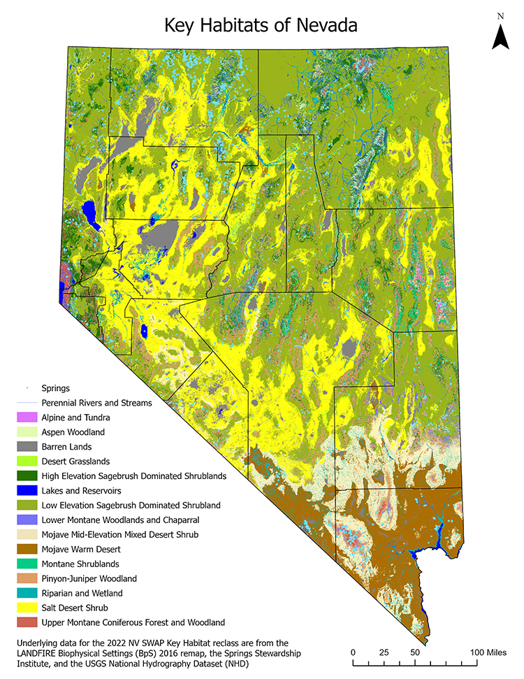
State Wildlife Action Plans, or SWAPs, are comprehensive, statewide plans for conserving wildlife and habitat resources. Updated every 3 to 10 years, depending on the state, SWAPs are designed to address the eight required elements needed to participate in the State Wildlife Grants Program. When staff and partners from the Nevada Department of Wildlife (NDOW) set out to begin our required 10-year revision to the Nevada SWAP, we hoped to create decision support tools that would lead to landscape-scale, cross-jurisdictional collaborations. Because fish, wildlife, and habitat resources span state and jurisdictional boundaries, we sought continuous, reliable data to support our analysis. Ideally, we hoped to base our SWAP on data that spanned state lines, was widely backed by subject matter experts, could be utilized for a variety of purposes, and would be supported and updated into the future.
We decided to use LANDFIRE data as the foundation for NDOW’s SWAP habitat analysis. LANDFIRE products allowed NDOW staff to:
Having the ability to estimate how vegetation has changed over time and measure the implications of these changes paves the way for NDOW to support ongoing threat analyses and planning to assist with siting conservation projects.
An additional key outcome of this process was a Habitat Climate Change Vulnerability Analysis based on NatureServe’s HCCVI process that utilizes LANDFIRE data. NatureServe's HCCVI analysis incorporates climate exposure and ecosystem resilience to estimate climate change vulnerability. This allowed seamless integration of our output that led to spatially explicit projections of climate change vulnerability that can be viewed at the Biophysical Setting (ecosystem) level or aggregated up to broader habitat management levels. These products are critical as we consider the future of Nevada’s natural resources in a changing world.
TNC's LANDFIRE staff were incredibly supportive at multiple steps of this process. Discussions with staff not only helped guide our analysis, but also led to collaboration with NatureServe and other partners that helped NDOW modernize and update our habitat mapping products. The outputs of this process will lead to the prioritization of targeted conservation efforts based on spatially explicit products that can be combined with other NDOW products such as big game migration corridors or critical habitat for species of conservation concern.
We relied on the LANDFIRE 2016 Remap data and plan to update our analysis as LANDFIRE moves to annual updates of Existing Vegetation Type, Height, Cover and other layers. Biophysical Settings products, reference condition, and succession class data were critical to our workflow for this SWAP revision. The availability of LANDFIRE’s nationwide products supports multiple natural resource management and scientific endeavors, and (perhaps most importantly) these data and products provide a common language and basis for making meaningful natural resource decisions.
We estimate the Nevada SWAP revision will be complete in early 2023. Check their website for the full report.
 |
 Habitat Biologist, Lee Davis presented on this process at a LANDFIRE Office Hour in 2022, check out the recording to the left to learn more about the process. Habitat Biologist, Lee Davis presented on this process at a LANDFIRE Office Hour in 2022, check out the recording to the left to learn more about the process.
|