General
LANDFIRE Standard Projections
CONUS
Projection type: USA Contiguous Albers Equal Area Conic (referenced as NAD_1983_CONUS_Albers (EPSG:5070))
Spheroid name: GRS 1980
Datum name: NAD83
Latitude of 1st parallel: 29.50 N
Latitude of 2nd parallel: 45.50 N
Longitude of central meridian: -96.00 W
Latitude of origin of projection: 23.00 N
False easting at central meridian: 0.0 meters
False northing at origin: 0.0 meters
Puerto Rico/Virgin Islands (PR/VI)
Projection type: USA Contiguous Albers Equal Area Conic (referenced as NAD_1983_CONUS_Albers (EPSG:5070))
Spheroid name: GRS 1980
Datum name: NAD83
Latitude of 1st parallel: 29.50 N
Latitude of 2nd parallel: 45.50 N
Longitude of central meridian: -96.00 W
Latitude of origin of projection: 23.00 N
False easting at central meridian: 0.0 meters
False northing at origin: 0.0 meters
Alaska
Projection type: Alaska Albers Equal Area (referenced as NAD_1983_Alaska_Albers (EPSG:3338))
Spheroid name: GRS 1980
Datum name: NAD83
Latitude of 1st parallel: 55.000 N
Latitude of 2nd parallel: 65.00 N
Longitude of central meridian: -154.00 W
Latitude of origin of projection: 50.00 N
False easting at central meridian: 0.0 meters
False northing at origin: 0.0 meters
Hawaii
Projection type: Albers Equal Area (referenced as Hawaii_Albers_Equal_Area_Conic (ESRI:102007))
Spheroid name: GRS 1980
Datum name: NAD83
Latitude of 1st parallel: 8.00 N
Latitude of 2nd parallel: 18.00 N
Longitude of central meridian: -157.00 W
Latitude of origin of projection: 13.00 N
False easting at central meridian: 0.0 meters
False northing at origin: 0.0 meters
Insular Areas (IA)
Projections are in best fit WGS 1984 UTM for Northern and Southern Hemispheres
LF users can download the CONUS, Alaska, Hawaii and Puerto Rico/Virgin Island Mapzone Extent shapefiles, which CONUS and Alaska includes both the 90k and 0k shapefiles, from our Data page.
LANDFIRE products were designed to support national, regional, and sub-regional analysis activities.
Considerations:
- The native spatial resolution of LANDFIRE raster spatial products is 30-meters, however, the appropriate application scale is much larger than 30 meters, and will vary by a combination of product, location, and specific use.
- Users should refer to the metadata and local, regional or expert knowledge to determine if LANDFIRE products are appropriate for their application in their area.
- LANDFIRE products are not intended to replace local products, but serve as a rich supplemental data source with complete areal coverage, regardless of ownership.
| What do you want to cite? | Model | Example |
| General information from www.landfire.gov | Homepage title. (Last update). [Homepage of], [Online]. Available: URL [Access date]. | LANDFIRE. (2013, January - last update). [Homepage of the LANDFIRE Project, U.S. Department of Agriculture, Forest Service; U.S. Department of Interior], [Online]. Available: https://www.landfire.gov [2013, February 8]. |
| LANDFIRE spatial data products | Homepage title: Data product. (Last update). Agency. [Online]. Available: URL [Access date]. | LANDFIRE: LANDFIRE Existing Vegetation Type layer. (2013, June - last update). U.S. Department of Interior, Geological Survey, and U.S. Department of Agriculture. [Online]. Available: https://landfire.gov/viewer/ [2013,May 8]. |
| LANDFIRE non-spatial data products | Homepage title: Data Product. (Last update). [Homepage of], [Online]. Available: URL [Access date]. | LANDFIRE: LANDFIRE Vegetation Dynamics Models. (2013, June - last update). [Homepage of the LANDFIRE Project, U.S. Department of Agriculture, Forest Service; U.S. Department of Interior], [Online]. Available: https://www.landfire.gov/ [2013, May 8]. |
- Install the Raster Attribute Table (RAT) plugin, install: https://plugins.qgis.org/plugins/RasterAttributeTable/
- Add the raster file to QGIS
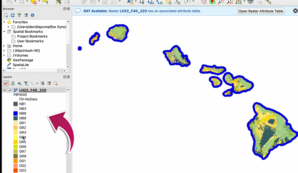
- If a RAT exists you will see the RAT available bar, shown below
- If data was downloaded from LF Viewer or from the website page for Mosaic Downloads, the attribute table is included
- If data was downloaded from the LFPS tool, an attribute table can be found on the product page.

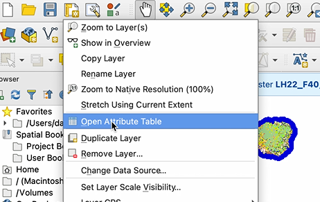
- If you do not see the RAT available bar, right click on the raster file, and either select your attribute table, or add your attribute table
- Open the RAT

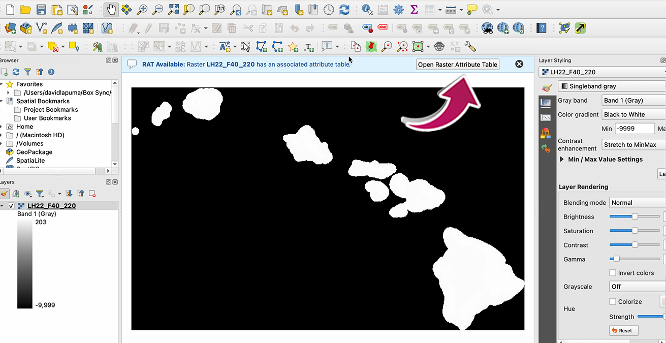
- Select your Classification from the drop-down: (FBFM40) Red, Green, or Blue

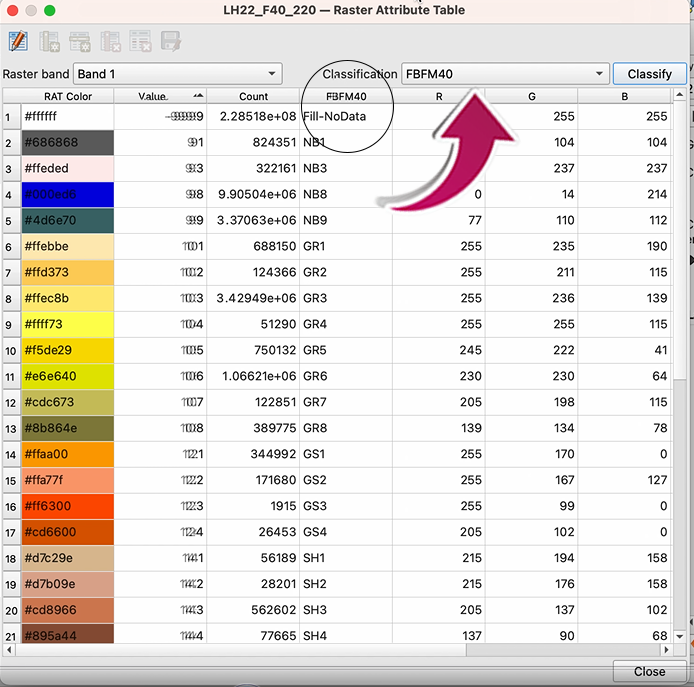
- Click on the Classify button
- A pop-up window will ask if you want to overwrite the existing classification--select YES
- The attribute table should now appear in QGIS.

A LANDFIRE Landscape GeoTIFF (landscape) file is a multi-banded raster. The data type for all bands is 16-bit signed integer. Bands are interleaved by pixel. Five bands are required: elevation, slope, aspect, fuel model, and tree canopy cover. You can download either Fire Behavior Fuel Models 13 (Anderson, 1982) or 40 (Scott and Burgan, 2005) as a landscape file using the map viewer with the “Data Download Tool”.
An update program is vital to support the full spectrum of fire and natural resource management programs with timely and quality products that reflect recent changes in landscape conditions. The LANDFIRE updates focus on landscape changes to vegetation and fuels resulting from disturbance and treatment activities such as wildland fire, fuel and vegetation treatments, mortality from insects and disease, storm damage, invasive plants, and other natural or anthropogenic events. Areas of concern will be improved through the LANDFIRE update process, and the existing layers will be updated to reflect more current conditions.
Our suggestion is to consider your intended use. LF native projection, USA Contiguous Albers Equal Area Conic (NAD_1983_CONUS_Albers or NAD_1983_Alaska_Albers), is perfect for larger area analysis, such as multiple states, etc. However, when doing any other types of analysis, such as local analysis, one may need to adapt LF products. If you are using software applications like FlamMap or FARSITE, it is best to reproject the products and use a north up projection, such as Best-FIT UTM (NAD83). If data are not reprojected to a north up projection, models could produce unexpected results. It's good practice to understand the map projection characteristics of the products and, when necessary, reproject them to best fit your needs. LF viewer download options allow you to choose NAD 1983 Albers (Standard Projection) or Best-Fit UTM (NAD83 Datum).
We need data that can be used to update LANDFIRE data layers, and data that could be used to remedy known concerns with previous versions. In a nutshell, we need Event data on any recent (current update cycle) disturbances or vegetation/fuel treatments that would have altered the composition or structure of vegetation and/or fuel. In addition to Event data, LANDFIRE also benefits from point or polygon vegetation or fuel plot data which may be incorporated in the LANDFIRE Reference Database (LFRDB).
ArcGIS
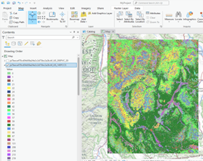
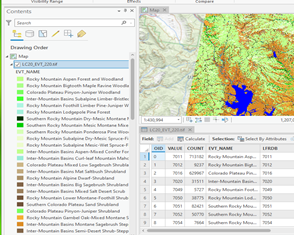
A significant aspect of managing each map layer is the ability to set a wide array of layer properties in the Properties dialog box. To display as LANDFIRE displays on the viewer:
ArcMap:
- Right click the layer in ArcMap
- Click on Properties
- Click on Symbology
- Select Unique Values
- In Value Field use the dropdown to select the desired field
- To display your data in the same way that the map viewer does, select the "Name or Label" field
ArcPro:
- Right click on the layer in ArcPro and select Symbology
- A dialog box will open, under Primary Symbology select Unique Values from the dropdown list
- Below that box, you will see Field 1, use the dropdown to select the desired field for display
- To display your data in the same way that the map viewer does, select the "Name or Label" field
It may also be helpful to review the "Setting layer properties" on the ArcMap web page or ArcPro web Page prior to working with LANDFIRE products.
With the release of the new viewer, ArcGrid, LFDAT, and Non-ESRI scripting (data access ESRI tools and formats) were archived. LF is changing technology to move with the industry towards GeoTIFF. As a result, ArcGrid will no longer be supported as we move technologies to Open Geospatial Consortium (OGC) standards.
LANDFIRE Product Service (LFPS)
LFPS produces multi-band GeoTIFFs which are multi-band floating-point raster datasets. Because raster attribute tables can only be built for single-band integer raster datasets, multi-band GeoTIFFs cannot have an attribute table joined. To remedy this, you can export individual bands from the LFPS output and join with an attribute table.
LF Attribute Tables are in the Comma Separated Value (CSV) format. To find the appropriate .csv file, go to the product pages and select the Comma Separated Value (CSV) link. Download the .csv file(s) and then follow the steps detailed in the instructions below:
Note: Since these are multi-band GeoTIFFs, drag-and-drop into ArcPro will not work. Users must use the recommended process of clicking on "Add Data" to bring their GeoTIFF into ArcPro.
ArcMap/ArcGIS Pro
- Click the Add Data dialog box (this is different for ArcMap vs ArcGIS Pro)
- Click on the file name of the LFPS GeoTIFF (make sure you expand the zip file first)
- Select and add the individual band(s) to which you want to join attributes
- Export each band as format TIFF
- In the Layer Properties menu, change the symbology in each band to Unique Values and select Yes to build a raster attribute table
- Join the attributes based on Value and the relevant attribute table (.csv) table
- Export the raster again to make the join permanent
As shown in the images below, the categorial information is missing from the multi-band GeoTIFF downloaded from LFPS, but after joining the attribute table to the individual exported raster, the attribute information is present.
![]()
| ![]()
|
The LFPS can be accessed in several ways:
- ESRI's REST API/Web Interface at https://lfps.usgs.gov/arcgis/rest/services/LandfireProductService/GPServer
- Python, php, unix wget, or anything that can call a URL (including an internet browser)
- Scripting tools like Postman (https://www.postman.com/)
LF Product Service (LFPS) is a RESTful Application Programming Interface (API) that allows users to request and download a LF products file, an output file incorporating the requested product layers via a multiband raster, through an API using HTTPS requests. Features of the LFPS include:
- Resampling product layers to a coarser resolution, defining an output projection for a study area, and editing select product layers based on rules using other product layers within the products file
- 100% RESTful
- Supports GET & POST for Endpoints
- All Downloads Endpoint(s) support Cross-Origin Resource Sharing (CORS)
- Asynchronous by default
Canopy Fuel Products
Canopy base height (CBH) and canopy bulk density (CBD) are calculated using the program FuelCalc designed by Elizabeth Reinhardt of the Missoula Fire Sciences Laboratory. This program ingests plot data — including species, diameter at breast height (DBH), height, height to live crown, canopy cover, and trees per acre — and computes CBD using species-specific allometric relationships. CBH is assumed to equal the height at which CBD becomes 0.012 Kg m-3.
Note that these lines exist in the Existing Vegetation Type layer as well. These lines result form radiometric oddities in the satellite imagery used to create these layers. This phenomenon generally occurs on the seam where two satellite overpasses from different dates were mosaicked to produce a seamless coverage of each zone. Since satellite imagery serves as a predictor of canopy base height (CBH) and canopy bulk density (CBD), the lines are "stamped" onto the resulting CBH and CBD layers.
Canopy characteristics refer only to the canopy of trees. Where there are tree canopies (in other words, existing vegetation types that are forest or woodland), LANDFIRE has attributed the grid with canopy characteristics. However, there will be no canopy characteristics in fuel types where the tree canopy is considered a part of the surface fuel and the surface fire behavior fuel model is chosen as such. This is because LANDFIRE assumes the potential burnable biomass in the tree canopy has been accounted for in the surface fuel model parameters. For example, young or short conifer stands where the trees are represented by a shrub type fuel model will not be attributed with canopy characteristics. These maps were developed for use in the FARSITE and FlamMap fire behavior applications (visit FARSITE for more information on these applications).
Surface Fuel Products
We create rule sets based on existing vegetation type, existing vegetation cover, existing vegetation height, and environmental site potential. We assign a fire behavior fuel model to each rule set and then engage local experts to review and calibrate the rules and resulting maps. Full descriptions of the LANDFIRE fire behavior fuel model products can be found in the Fuel Data Products Overview.
Slash is not practically detectable using the 30-m resolution Landsat satellite imagery, especially where overstory is present. We therefore do not employ the slash models except in rare instances where local experts determine that the slash models give the best representation of the expected fire behavior. For example, slash models best represent areas of very thick blow-down where fuel loads exceed those depicted in FBFM10.
LANDFIRE 2016 Remap
LF Remap mapping efforts use 2013 - 2017 imagery. Priority was given to imagery from 2016.
LF Total Fuel Change Tool (LFTFC)
LF breaks the table down into zones which makes it a little easier to deal with. In the LFTFC toolbar it makes the management unit GRID of the zone/area of interest then copies the attribute table to the database and that is the _cmb table for that area. The rulesets table assigns the fuels to the appropriate fields in the _cmb then the table is joined back to the GRID, where LFTFC does a lookup function on the fuel field the user is interested in, for a GRID product.
The LF Program realizes there is time between when a mechanical remove disturbance happens and when the activity fuels from it are treated, but LF assumes that activity fuels are being treated shortly after. This is what LF uses for multiple entries, in this order:
- High severity fire. Has probably the most impact on the landscape
- High severity mechanical remove. We assume that most of the overstory is removed, site prep for planting takes place, and then planting
- All other fires ranging from moderate to low severity fires
- Whichever happened most recent of the remaining disturbances
- If only one disturbance occurred, then that is the one assigned
It would be ideal to be able to track every activity through its full progression, but there is not a good way for LF to do that for all the U.S. in a timely manner. In addition, private landowners typically do not report disturbance activities and some areas in the U.S. treat activity fuels differently, such as reducing the fuel bed depth and having high rates of decomposition to take care of them in a timely manner. It is easier when the LF team remotely detects disturbances to assume the activity fuels are being treated appropriately according to regulations.
Reference Products
If you have questions or would like to submit data please contact Brenda Lundberg, LANDFIRE Reference Data Administrator. You may email datasets smaller than 25MB to blundberg@contractor.usgs.gov. If the files are too large to send via email please contact Brenda Lundberg for alternative file transfer options.
Brenda Lundberg,
blundberg@contractor.usgs.gov
We will accept Event data (disturbance and vegetation/fuel treatment data) in various formats, including ESRI shapefiles, geodatabases, and ArcInfo coverages. Supporting information, including definitions of the fields and any codes in the data tables, should accompany the data to ensure that they can be interpreted correctly. If you have LFRDB data (vegetation and/or fuel plot data) to share, we're even more flexible in terms of data format. We'll gladly accept digital data in, text files, spreadsheets, relational databases, ESRI shapefiles or geodatabases, and ArcInfo coverages - whichever is most convenient for the contributor. Coordinate information, including map datum, can be bundled with the other attribute information or in a separate, linked file, or data form. Supporting information, including definitions of the fields and any codes in the data tables or data-entry forms, should accompany the data to ensure that they are accurately represented in the LANDFIRE reference database.
LANDFIRE does draw data from several web based data clearing houses including the NPS Data Store, USGS/NPS Vegetation Characterization Website, and USFS Regional Data Clearing houses. LANDFIRE also acquires data from agency/corporate database systems such as USFS FACTS (Forest Service Activity Tracking System) and USFS NRIS (Natural Resource Information System). The Website Agency DB Table provides a complete list of websites or agency database systems from which LANDFIRE draws data. If you store data on one of the websites or agency databases listed in this table, please verify that a current version of your data are posted to ensure that this data will be evaluated for use in the next LANDFIRE update cycle.
The annual data submission deadline is October 31st of each year. Please make every effort to submit your data by October 31st of each year, as LF is relying heavily on user contributed data for this update. Data submitted after the deadline will be used if schedules allow or be archived for future use. All data contributions must meet LF requirements.
Vegetation Products
Vegetation data is assessed using a combination of two techniques:
- quantitative, site specific agreement assessment by map zone and groups of map zones using withheld field plots
- case studies in selected areas
Learn more about Data Product Quality.
Vegetation Condition Class (VCC) and Vegetation Departure (VDep) are the same data that was previously called Fire Regime Condition Class (FRCC) and Fire Regime Departure Index (DEP). According to the FRCC Guidebook, FRCC was an interagency tool used to determine the degree of ecological departure from historical, or reference condition, vegetation, fuels, and disturbance regimes. FRCC, a combination of vegetation departure, fire frequency, and severity departure, were measures of vegetation departure, hence the name change.
PV is the vegetation capable of existing given the biophysical characteristics of a site. PV integrates current regional climate and physical site characteristics.
LANDFIRE characterizes PV in two ways:
- Environmental Site Potential (ESP) is the vegetation that would become established at late or climax stages of successional development in the absence of disturbance (pre European). ESP reflects the dates of the input data used in the mapping process (approx. 1980-2004 for field data and 1980-1997 for biophysical gradient layers developed from DAYMET data). It also includes the competitive potential of native plant species. The ESP layer informs vegetation and fuel mapping.
- Biophysical Settings (BpS) is a refinement of ESP and incorporates natural ecological disturbance processes, such as fire. The biophysical settings (BpS) layer represents a composite time period that includes the "current" input data, the historical context provided by vegetation dynamics models, and assumptions about fire regimes. It forms the basis for linking ecological processes of succession to landscapes, which is used to simulate historical vegetation and disturbance characteristics.
Summary units for vegetation departure calculations varied across the LANDFIRE versions and are specified on the Vegetation Departure web page.
LANDFIRE (LF) never delivered "full" Fire Regime Condition Class (FRCC) even when the product carried that name, so it was renamed to reduce confusion.
FRCC is composed of two elements: Vegetation Departure and Fire Regime Departure. LF produced and delivered the first component of FRCC (Vegetation Departure) because LF had no consistent way to estimate Fire Regime Departure over the entire geography. Therefore, the product was renamed Vegetation Condition Class (VCC) since it is a more appropriate and descriptive name. VCC is Vegetation Departure sliced into categories.
Layers of existing vegetation type (EVT) and structure are used in LANDFIRE's modeling and mapping of wildland fuel, fire regimes, and ecosystem status. Further, LANDFIRE vegetation products characterize existing vegetation composition and structure and thus prove useful in various land management applications.

