

The LANDFIRE 2023 Update (LF 2023) product suite represents the final step in the ongoing goal to move towards annual updates and reduced latency. LANDFIRE'S goal has been to release an annual update every year that represents one year, specifically the previous year. Similar to the LF 2022 Update, in LF 2023, disturbances from the previous year are represented in current year products. The LF 2022 Update was the first map product suite in which disturbances from the year prior are represented in current year products. Continuing the work of the annual vegetation and fuel updates, the LF 2023 Update suite provides updated layers that add to, and account for disturbance on the landscape that has occurred through October of 2023. This means the LANDFIRE team has been able to improve production efficiencies and turn around disturbances faster than ever, providing our community of users the newest data faster.
Improvements Featured in the LF 2023 Update
- The use of 4 seasonal composites in disturbance mapping, doubling LANDFIRE’s use of satellite imagery
- Mapped disturbance events in the 90km buffer area surrounding the Conterminous United States (CONUS)
- Two new types of Annual Disturbance products – Limited and Preliminary Annual Disturbance
- New fuels calibration for the Southeast GeoArea, Colorado, and Oklahoma
- An updated Operational Roads product for CONUS that incorporates National Land Cover Database (NLCD) 2021
- The return of Fire Regime Group (FRG), Fire Return Interval (FRI), and Percent Fire Severity (PFS) as standalone products. The products will be applicable to LF 2016 Remap for CONUS and HI
- Updated BPS, FRG, FRI, and PFS products for AK
- An updated Fuel Characteristics Classification System (FCCS) product for all extents
- Sampled GEDI canopy height data as additional training data for the tree height model
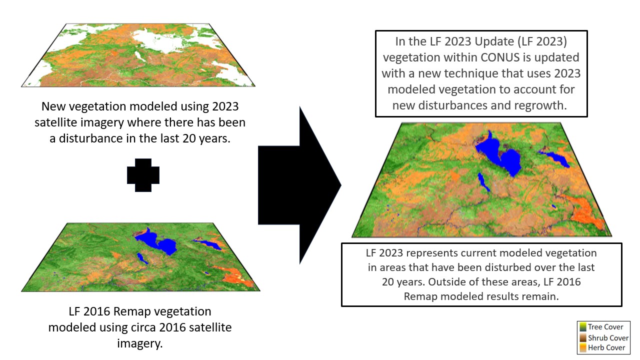
A new methodology update for Existing Vegetation Cover (EVC), Height (EVH), and Type (EVT) products within CONUS
In the past LANDFIRE updates have used millions of rulesets developed from local and national experts across the United States to update mapped vegetation where disturbance has occurred. These rulesets considered the initial vegetation type, cover, and height and applied a transition rule using the disturbance type, severity, and length of time since the disturbance occurred to produce an updated EVT, EVC, and EVH products for a new version.
Since circa LF 2016 Remap (LF Remap), these rules have required to Remap inputs of EVT, EVC, and EVH. This created challenges for the update process because areas that had been disturbed in the few years prior to 2016 remained unchanged from that snapshot in time.
For LF 2023, LANDFIRE will map the lifeform, cover, and height of existing vegetation in areas that LANDFIRE has mapped as disturbed over the last twenty years (see the LANDFIRE Annual Disturbance product) using our machine learning methods. LANDFIRE focused on updating areas disturbed over the last 20 years since these are the areas that have most likely changed the most.

NEW Products included in LF 2023
To provide sooner delivery of LANDFIRE Annual Disturbance data and to ensure a more complete record, LANDFIRE has decided to distribute more Annual Disturbance products.
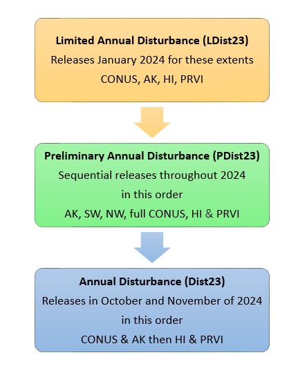
What does this change mean? There are now three Annual Disturbance products released in a single version – each with a unique name and identity.
Limited Annual Disturbance (LDist) is a new product making its debut with the LF 2023 Update. LDist is designed to provide a first cut of landscape change information as soon as possible to support time-sensitive updates such as risk management efforts. This early release does not include satellite change detection to capture additional disturbances and does not provide image-based severity for contributed events. Some fire program data includes severity which is present in the LANDFIRE LDist product. However, many fires and disturbance events lack severity assignments, therefore LDist severity is a default based on disturbance type (Clearcut = High Severity, Wildfire = Medium Severity, all others including prescribed fire = Low Severity).
LDist includes data inputs from the following sources:
- Fire program perimeters and burn severity where available from four sources: Monitoring Trends in Burn Severity (MTBS), Burned Area Reflectance Classification (BARC), Rapid Assessment of Vegetation Condition after Wildfire (RAVG), Landsat Burned Area (BA)
- Event polygon datasets submitted from three national contributors: US Bureau of Land Management (BLM), National Park Service (NPS), and the US Fish and Wildlife Service (USFWS)
- Event polygon datasets obtained from four online national sources: Forest Service Activity Tracking System (FACTS), Interior Fuels & Post-fire Reporting System (IFPRS), National Interagency Fire Center (NIFC), USFS National Insect and Disease Risk Map (NIDRM)
The LDist product featured in the LF 2023 update (named LDist23) is the first of three Annual Disturbance products being released in 2024. LDist23 is an early "draft" of the LANDFIRE Annual Disturbance product and includes fires, disturbance events, and land management activities for Fiscal Year 2023 (FY2023) from trusted national sources obtained in November 2023.
Preliminary Annual Disturbance (PDist) is another new product making its debut with the LF 2023 Update. PDist is designed to provide a second "draft" of landscape change information and will have multiple extent releases throughout 2024:
- Conterminous United States (CONUS) – by GeoArea
- Alaska (AK)
- Hawaii (HI)
- Puerto Rico and the U.S. Virgin Islands (PRVI)
PDist includes disturbance events for FY2023 from regional sources obtained in November 2023. Additionally, similar to annual disturbance products in past versions, PDist includes results from LANDFIRE satellite change detection and image-based severity. A complete list of data contributors can be found here: LANDFIRE Program: Contribute Data - Previous Contributions (usgs.gov).
The PDist product featured in the LF 2023 Update (named PDist23) will be used to update the Vegetation, Fuel (including Fuel Disturbance), and Fire Regime suite of products included in releases throughout the rest of 2024.
The Final Annual Disturbance (Dist) product is the "final" draft of Annual Disturbance data for a give version. The Annual Disturbance product included in the LF 2023 Update (named Dist23) releases beginning in the fall of 2024. Compared to PDist23, Dist23 includes additional fires and disturbance events for FY2023, these events were harvested from a second "pull" of the national online sources in June 2024.
- The Public Events Geodatabase for LF 2023 releases in late 2024 and will include events captured from this second "pull".
- The events harvested from the second "pull" will not be incorporated into the production of Fuel Disturbance (FDist23) and other Fuel, Vegetation, and Fire Regime products for the LF 2023 Update. These events will be included in the next version (coming in 2025).
LF 2023 Update Products and Descriptions
| THEME | PRODUCT NAME | ABBREVIATION |
|---|---|---|
| Disturbance | Limited Disturbance | LDist23 |
| Preliminary Annual Disturbance | PDist23 | |
| 2023 Annual Disturbance | Dist23 | |
| Historical Disturbance | HDist23 | |
| Fuel Disturbance | FDist23 | |
| Historic Fire Regime | Fire Regime Groups | FRG |
| Fire Return Interval | FRI | |
| Percent Fire Severity | PFS | |
| Fuel | 13 Anderson Fire Behavior Fuel Models | FBFM13 |
| 40 Scott and Burgan Fire Behavior Fuel Models | FBFM40 | |
| Forest Canopy Bulk Density | CBD | |
| Forest Canopy Base Height | CBH | |
| Forest Canopy Cover | CC | |
| Forest Canopy Height | CH | |
| Canadian Forest Fire Danger Rating System | CFFDRS | |
| Operational Roads | Roads | |
| Fuel Vegetation Cover | FVC | |
| Fuel Vegetation Height | FVH | |
| Fuel Vegetation Type | FVT | |
| Fuel Rulesets Database | FRDB | |
| Fuel Characteristic Classification System Fuelbeds | FCCS | |
| Reference | Public Events Geodatabase | EventsDB |
| Public Exotics Geodatabase | ExoticsDB | |
| Public Model Ready Events Geodatabase | ModelReadyDB | |
| Vegetation | Biophysical Settings | BPS |
| Existing Vegetation Type | EVT | |
| Existing Vegetation Cover | EVC | |
| Existing Vegetation Height | EVH | |
| Succession Classes | SClass | |
| Vegetation Condition Class | VCC | |
| Vegetation Departure Index | VDep |
LF 2023 Update Schedule
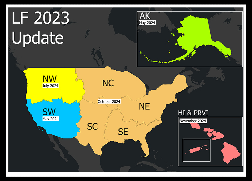
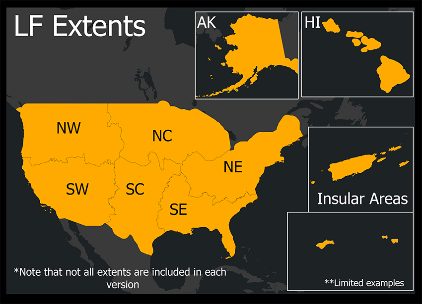
LF 2023 is being released by Conterminous United States (CONUS) GeoArea beginning in May 2024 with the SW along with Alaska (AK). Remaining GeoAreas, Hawaii (HI), and select Insular Areas (IA), Puerto Rico and the US Virgin Islands (PRVI) will be later in the year.
| January 2024 | Limited LDist CONUS, AK, HI, IA |
|---|---|
| Early May 2024 | AK |
| Late May 2024 | CONUS (SW) |
| July 2024 | CONUS (NW) |
| September 2024 | Annual Disturbance (CONUS, AK) & Public Events GDB (all extents) |
| October 2024 | CONUS (full extent) |
| November 2024 | HI, IA (PRVI) |