


Contribute Your Data to LANDFIRE
LANDFIRE would like to acknowledge and thank everyone who has contributed data. We rely on high-quality disturbance, treatment, vegetation, and fuel data from agencies and partners to maintain accurate landscape products. User contributions help ensure we can produce reliable annual updates.
Contribute Your Disturbance & Treatment Polygons
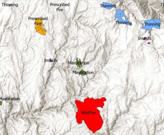
Disturbance and treatment polygons (also known as events) are a top priority for annual updates and are stored in the LF Disturbance and Treatment Polygon Geodatabase (formerly known as the Events Geodatabase). Refer to the LANDFIRE Data Collection Requirements for required attributes. LF processes data by fiscal year and requires that the disturbance/treatment date or federal fiscal year be included with all data submissions.
Collection Dates: October 1st (previous year) through September 30th (current year).
Deadline to Submit: All submissions must be in partner systems or emailed to LANDFIRE by October 31st.
Database Pulls: LF always pulls data from USDA Forest Service Activity Tracking System (FACTS), Interior Fuels & Post-fire Reporting System (IFPRS), National Interagency Fire Center (NIFC)/(InFORM), and USFS Insect/Disease. The Contributing Agency Database, linked below in Supplemental Resources, lists other websites or agency databases that LF has collected data from. If your dataset is listed in the database, confirm it has been updated and submitted prior to the September 30th deadline every year.
Data Format: We accept data in various formats including map services, ESRI shapefiles, geodatabases, and ArcInfo coverages. Supporting information, including definitions of the fields and any codes in the data tables, should accompany the data to ensure correct interpretation.
Submit Data Directly to LANDFIRE: All data should be submitted to Brenda Lundberg, LANDFIRE Reference Data Administrator at blundberg@contractor.usgs.gov.
Current Data Call Letter For LF 2026
Check out LF Contributed Data Table to search all past data contributors!
State Contributors
LANDFIRE relies on state and local data to help fill holes and create the best products possible. While LF may receive some data through federal databases, we are also looking for state treatment and disturbance data.
LANDFIRE is now collaborating with the National Fuels Treatment Database (NFT) and State treatment data and polygons will be gathered from their comprehensive database. LANDFIRE is striving to reduce reporting demands for state-level GIS, forest, and fire managers to create a more efficient reporting process.
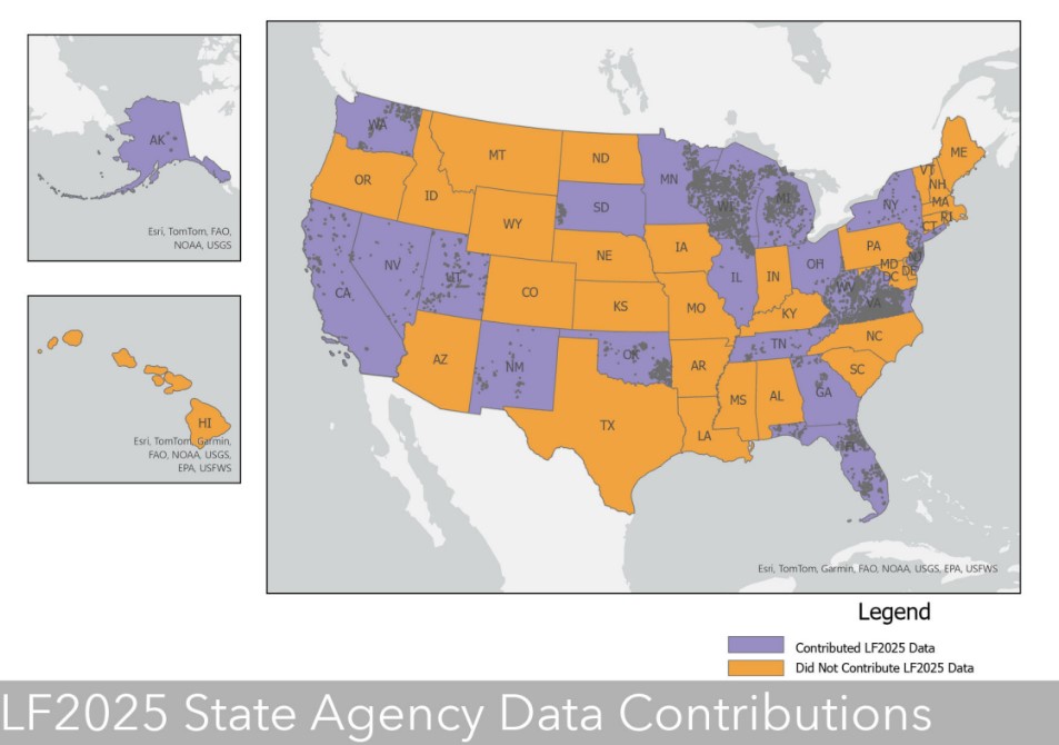
The map below shows the states where state agencies did and did not submit disturbance and treatment data for LF 2025. If your state is colored purple, it indicates that LF received disturbance and treatment data from your state agencies, with the contributed polygons shown. All states colored orange, show where LF can use state contributed data! Map does not show contributions from NIFC/InFORM or Federal Agencies.
Your Disturbance and Treatment Polygons at Work
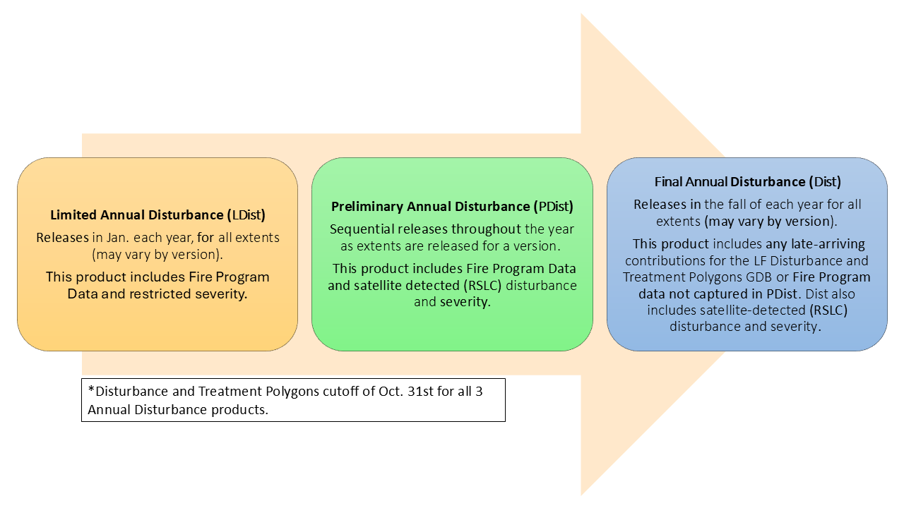
So, you submitted your data and you want to know when it will show up. LANDFIRE creates and releases an early, Limited Annual Disturbance (LDist) product that uses only National federal events including FACTS, IFPRS, NIFC, USFS Insect/Disease. We also get National data submissions from the Bureau of Land Management (BLM) and the National Park Service (NPS).
The Preliminary Annual Disturbance (PDist) product is sequentially released with each Geographic Area. All submitted state and local disturbance and treatment polygons collected by the October 31st deadline are included in the PDist product and are what feeds into the Vegetation and Fuels products.
A final pull from Federal databases is done early June, with these events being added to the Final Annual Disturbance (Dist) product. Final Annual Disturbances will only influence Vegetation and Fuels products for the next years’ products.
Other Data We Collect
Vegetation and fuel plot data provide training data for vegetation modeling; contributed plots are kept in the LF Reference Database (LFRDB). New plot data with species cover information can be used for annual updates, and repeat measurements of plots are also welcome.
Collection Dates: LF accepts all dates for LFRDB plot data
Deadline to Submit: No deadline
Database Pulls: LF always pulls data from Forest Inventory and Analysis (FIA), Bureau of Land Management, Assessment Inventory and Monitoring (BLM-AIM), Natural Resource Conservation Service (NRCS) - National Resource Inventory (NRI), VegBank, U.S National Science Foundation's National Ecological Observatory Network (NEON), and Sagebrush Steppe Treatment Evaluation Project (SageSTEP). There are many other federal partners that we work with, and this is not an exhaustive list. We would also like to highlight work from the National Park Service (NPS) FEAT-FIREMON Integrated (FFI).
Submit Data Directly to LANDFIRE: All data should be submitted to Brenda Lundberg, LANDFIRE Reference Data Administrator at blundberg@contractor.usgs.gov.
Data Format:
- Tabular - text files, spreadsheets, relational databases
- Spatial - shapefiles, geodatabases, coverages
Supporting information, including definitions of the fields and any codes in the data tables should accompany the data to ensure correct interpretation. Project descriptions, final reports, data dictionaries, or plot photos are helpful where available.
The LFRDB Data Dictionary shows the attributes that LF archives from vegetation and fuel plot contributions. Not all attributes are needed for the data to be useful.
Partnership Contributors
LANDFIRE relies on federal, state, and local data to help fill holes and create the best products possible. While LF may receive some data through federal databases, we are also looking for state and local contributed vegetation and fuel treatment data.
LANDFIRE forms partnerships with many groups and organizations to enhance the richness of the LF Reference Database (LFRDB) and incorporates those contributions into the LF data production process.
Vegetation and fuel plot data provide training data for vegetation modeling; contributed plots are kept in the LF Reference Database (LFRDB). New plot data with species cover information can be used for annual updates, and repeat measurements of plots are also welcome.
Collection Dates: LF accepts all dates for LFRDB plot data
Deadline to Submit: No deadline
Database Pulls: LF always pulls data from Forest Inventory and Analysis (FIA), Bureau of Land Management, Assessment Inventory and Monitoring (BLM-AIM), Natural Resource Conservation Service (NRCS) - National Resource Inventory (NRI), VegBank, U.S National Science Foundation's National Ecological Observatory Network (NEON), and Sagebrush Steppe Treatment Evaluation Project (SageSTEP). There are many other federal partners that we work with, and this is not an exhaustive list. We would also like to highlight work from the National Park Service (NPS) FEAT-FIREMON Integrated (FFI).
Submit Data Directly to LANDFIRE: All data should be submitted to Brenda Lundberg, LANDFIRE Reference Data Administrator at blundberg@contractor.usgs.gov.
Data Format:
- Tabular - text files, spreadsheets, relational databases
- Spatial - shapefiles, geodatabases, coverages
Supporting information, including definitions of the fields and any codes in the data tables should accompany the data to ensure correct interpretation. Project descriptions, final reports, data dictionaries, or plot photos are helpful where available.
The LFRDB Data Dictionary shows the attributes that LF archives from vegetation and fuel plot contributions. Not all attributes are needed for the data to be useful.
Partnership Contributors
LANDFIRE relies on federal, state, and local data to help fill holes and create the best products possible. While LF may receive some data through federal databases, we are also looking for state and local contributed vegetation and fuel treatment data.
LANDFIRE forms partnerships with many groups and organizations to enhance the richness of the LF Reference Database (LFRDB) and incorporates those contributions into the LF data production process.
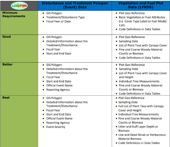
Good, Better, Best Data Collection Requirements
Linked below is a downloadable document showing all the attributes LANDFIRE requires, and optional data that we would love to receive with the data that is submitted for Disturbance and Treatment Polygons, and Vegetation and Fuel Plot data. You can download the document here.
FAQs
No. The production schedule does not allow time for the LANDFIRE team to go back and add from previous years.
No. The production schedule does not allow time for the LANDFIRE team to go back and add from previous years.
Yes! Previous years of Vegetation and Fuel plot data are accepted and included in the LFRDB.
Yes! Previous years of Vegetation and Fuel plot data are accepted and included in the LFRDB.
Your contributed data is used to reflect disturbed areas and for modeling in LANDFIRE Vegetation and Fuel products. These spatial data layers are consumed by countless federal fire behavior decision support tools and risk assessment applications as well as private industry. Some federal applications include: the US Department of Agriculture (USDA), Forest Service (USFS) Wildland Fire Decision Support System (WFDSS), the US Department of Interior’s Interagency Fuel Treatment Decision Support System (IFTDSS), the USDA USFS FlamMap and WindNinja applications and hazardous‑fuels prioritization tools.
Your contributed data is used to reflect disturbed areas and for modeling in LANDFIRE Vegetation and Fuel products. These spatial data layers are consumed by countless federal fire behavior decision support tools and risk assessment applications as well as private industry. Some federal applications include: the US Department of Agriculture (USDA), Forest Service (USFS) Wildland Fire Decision Support System (WFDSS), the US Department of Interior’s Interagency Fuel Treatment Decision Support System (IFTDSS), the USDA USFS FlamMap and WindNinja applications and hazardous‑fuels prioritization tools.
Refer to the LANDFIRE Data Collection Requirements for list of acceptable formats.
Refer to the LANDFIRE Data Collection Requirements for list of acceptable formats.
None — submit all disturbance and treatment polygons.
None — submit all disturbance and treatment polygons.
Most likely. Data does not need to contain the full suite of vegetation/fuel or disturbance and treatment activity information that is listed to be useful.
Most likely. Data does not need to contain the full suite of vegetation/fuel or disturbance and treatment activity information that is listed to be useful.
LF keeps contributed, non-public data internal when an agency notes it as proprietary. LF is also happy to enter into data sharing agreements.
LF keeps contributed, non-public data internal when an agency notes it as proprietary. LF is also happy to enter into data sharing agreements.
Resources
- LANDFIRE Data Collection Requirements - minimum information needed for each data type and additional attributes that are highly beneficial to improve data products and provides disturbance and treatment polygon data needs.
- LF Disturbance and Treatment Polygons (Events) Attribute Data Dictionary - shows the attributes that LF archives from disturbance and treatment data contributions.
- LF Reference Database (LFRDB) Attribute Data Dictionary - shows the attributes that LF archives from Vegetation and Fuel plot data contributions.
- Contributing Agency Database – downloads a zip file of a list of all websites and agency database from which LF pulls Disturbance and Treatment Polygon data and Vegetation Fuel Plot data.
- Developing Auto-Keys for LF Vegetation Mapping: 2014-2015 CONUS Project Report
- A LANDFIRE Disturbance explained - Understand how data impacts LANDFIRE.
- Disturbance Data Processing – description of how polygon data of disturbances and treatments are evaluated and processed into the Disturbance and Treatment Polygons (Events) geodatabase.
- Plot Data Processing – description of vegetation and fuel plot data requirements and how they are evaluated for use.
- Value of Georeferenced Vegetation Plots to LANDFIRE – Illustrated examples of how supporting data improved the LF Remap process.
- From Winter Storms to Better LANDFIRE Data - How Storms (and other Disturbances) show up in LANDFIRE
- LANDFIRE Data Collection Requirements - minimum information needed for each data type and additional attributes that are highly beneficial to improve data products and provides disturbance and treatment polygon data needs.
- LF Disturbance and Treatment Polygons (Events) Attribute Data Dictionary - shows the attributes that LF archives from disturbance and treatment data contributions.
- LF Reference Database (LFRDB) Attribute Data Dictionary - shows the attributes that LF archives from Vegetation and Fuel plot data contributions.
- Contributing Agency Database – downloads a zip file of a list of all websites and agency database from which LF pulls Disturbance and Treatment Polygon data and Vegetation Fuel Plot data.
- Developing Auto-Keys for LF Vegetation Mapping: 2014-2015 CONUS Project Report
- A LANDFIRE Disturbance explained - Understand how data impacts LANDFIRE.
- Disturbance Data Processing – description of how polygon data of disturbances and treatments are evaluated and processed into the Disturbance and Treatment Polygons (Events) geodatabase.
- Plot Data Processing – description of vegetation and fuel plot data requirements and how they are evaluated for use.
- Value of Georeferenced Vegetation Plots to LANDFIRE – Illustrated examples of how supporting data improved the LF Remap process.
- From Winter Storms to Better LANDFIRE Data - How Storms (and other Disturbances) show up in LANDFIRE