

Product Description
This page includes a general description of the product, please consult the schedule and version pages for information specific to each release.
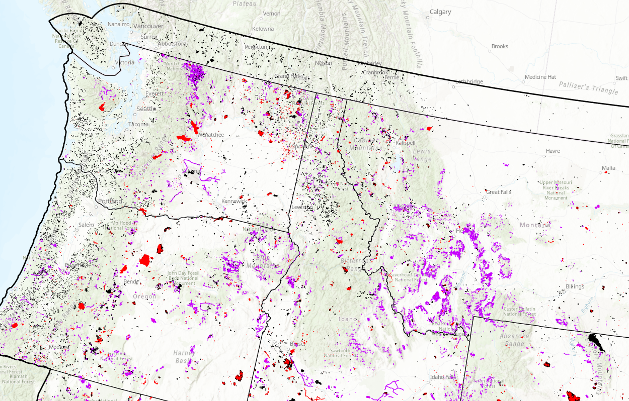
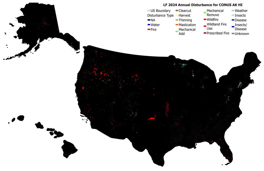
LANDFIRE’s Annual Disturbance products represent LANDFIRE’s comprehensive yearly assessment of landscape change across all lands in the United States (extending 90 km into Canada and Mexico) and U.S. territories. Disturbances - such as wildfires, vegetation removal or treatments, insect and disease damage, and other natural or management activities - shape ecosystems and influence vegetation structure, fuel conditions, habitats, and long-term ecological processes. The Annual Disturbance suite of products tracks and maps this change so land managers, scientists, planners, and analysts can make informed decisions.
In application, annual disturbance information serves a diverse number of roles, such as developing Potential Operational Delineations (PODs) for wildfire risk management, prioritizing fuels reduction and restoration activities, and monitoring forest health metrics in response to insect and disease outbreaks. Additionally, disturbance data is crucial because it acts as the "steering wheel" for updating LANDFIRE’s fuels and vegetation maps. For example, a high-severity fire or clearcut will transition a forest grid cell into an early-successional state (shrub/herbaceous), whereas a low-severity burn might only reduce the surface fuels while leaving the forest canopy intact.
To ensure these products remain versatile for varied applications, the disturbance information is standardized with key attributes that define its origin, timing, and impact. This structure allows users to effectively filter, query, and analyze landscape change across all GeoAreas. Each mapped disturbance is attributed with the following core information:
- Disturbance Year: Fiscal and calendar
- Disturbance Type: e.g., wildfire, mechanical treatment, insect/disease
- Severity: Magnitude of impact on the landscape’s vegetation
- Severity Source: Fire program data, Event submission, or remotely sensed change
- Detailed Descriptions: Plain-language descriptions of each attribute/value
LF 2016 Remap and beyond includes a 90-kilometer buffer along the 1,500 miles of the eastern and southern borders AK shares with Canada. Then with the LF 2020 update, and future updates, for the Conterminous United States (CONUS) a 90-kilometer buffer into Mexico is also included.
Annual Disturbance Products
Annual Disturbance Product Breakdown
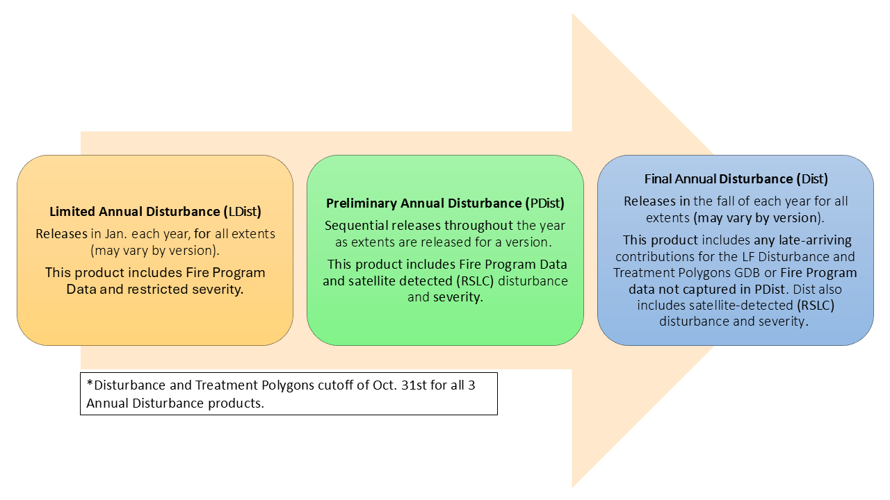
Limited Annual Disturbance - Single Release
Limited Annual Disturbance (LDist) made its debut with the LF 2023 Update. LDist provides a “first look” at the previous fiscal year’s reported disturbance and treatment polygons (events) and does not include change detected from satellite imagery. It incorporates submitted disturbance and treatment polygons that arrived before the start-of-year processing cutoff (November 1), and fire program data available up to mid-December. LDist is composed of data from the following sources:
- Fire program rasters and burn severity: Four possible sources, including Monitoring Trends in Burn Severity (MTBS), Burned Area Reflectance Classification (BARC), Rapid Assessment of Vegetation Condition after Wildfire (RAVG), and Landsat-derived Burned Area (BA).
- Event polygon datasets: Submitted from two national contributors - the US Bureau of Land Management (BLM) and the National Park Service (NPS).
- Online national Event datasets: Obtained from the USDA Forest Service Activity Tracking System (FACTS), National Interagency Fire Center (NIFC), USFS National Insect and Disease Risk Map (NIDRM), and the Interior Fuels and Post-fire Reporting System (IFPRS).
LDist is typically released from late January to mid-February, depending on data availability and processing timelines. It is provided as four datasets (CONUS, Alaska, Hawaii, and Puerto Rico/The Virgin Islands).
Preliminary Annual Disturbance - Incremental Release
PDist expands upon LDist by incorporating:
- Remotely sensed disturbance detections from satellite imagery.
- Image-based severity estimates for disturbance and treatment polygons (events) and satellite-detected disturbances.
PDist is considered the second “draft” and is released incrementally by GeoArea shortly after processing is complete. The PDist product featured in the current version will be used to update the Vegetation and Fuel (including Fuel Disturbance) products included in releases throughout the rest of the year.
Annual Disturbance - Single Release
Dist is the complete and final disturbance layer for the year. It incorporates:
- All data from LDist and PDist, including remotely sensed changes and severity assignments.
- National online disturbance and treatment polygon (events) submissions from the previous fiscal year that missed the initial submission deadline; this second data retrieval takes place during June and July.
- Fire program data from the previous fiscal year not available for inclusion in LDist or PDist, finalized during June and July.
Dist is LANDFIRE’s final and authoritative annual record of disturbance. It is important to note that the late-arriving disturbance and treatment polygons included in the Dist product are not incorporated into the current year’s Fuel Disturbance (FDist) or other fuel, vegetation, and fire regime products; those products are updated using the PDist product.
Annual Disturbance Resources
CONUS Limited Disturbance (LDist) All Years
Alaska Limited Disturbance (LDist) All Years
Hawaii Limited Disturbance (LDist) All Years
IA/Puerto Rico/Virgin Islands Limited Disturbance (LDist) All Years
CONUS Preliminary Disturbance (PDist) All Years
Alaska Preliminary Disturbance (PDist) All Years
Hawaii Preliminary Disturbance (PDist) All Years
IA/Puerto Rico/Virgin Islands Preliminary Disturbance (PDist) All Years
CONUS Disturbance All Years
Alaska Disturbance All Years
Hawaii Disturbance All Years
IA/Puerto Rico/Virgin Islands Disturbance All Years
Addressing Hurricane Helene's Disturbance: A Customized Mapping and Data Integration Solution
LANDFIRE's NEW Disturbance Products (and Severity Data) Explained
A day in the life of a LANDFIRE Disturbance Mapper
The Spatially Adaptable Filter for Error Reduction (SAFER) Process: Remote Sensing-Based LANDFIRE Disturbance Mapping Updates
Methods used to mitigate data gaps in LF 2012 and beyond.
A LANDFIRE Disturbance explained
Annual Nationwide Remote Sensing of Disturbance for LANDFIRE (2021)
Mapping Disturbance for the Conterminous United States in Less than Six Months: Exploring Improvements in Processing Power, Image Compositing, and Improved Change Detection Algorithms
Keeping LANDFIRE Data Current – It's a Matter of Disturbance
Monitoring Trends in Burn Severity