| Overview Area | Season | Region | Date Range |
|---|---|---|---|
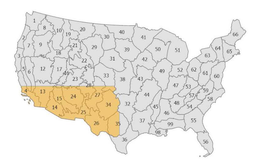 | Early Spring | Southwest | Feb 1 - April 20 |
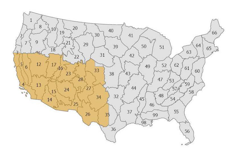 | Spring | Southwest Northern Great Basin | Feb 1 - May 20 |
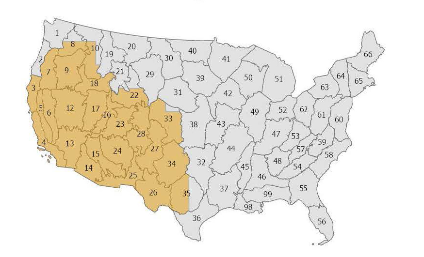 | Summer | Southwest Northern Great Basin Northern | Feb 1 - Jun 20 |
| Fall | Southwest | Feb 1 - Sep 20 |



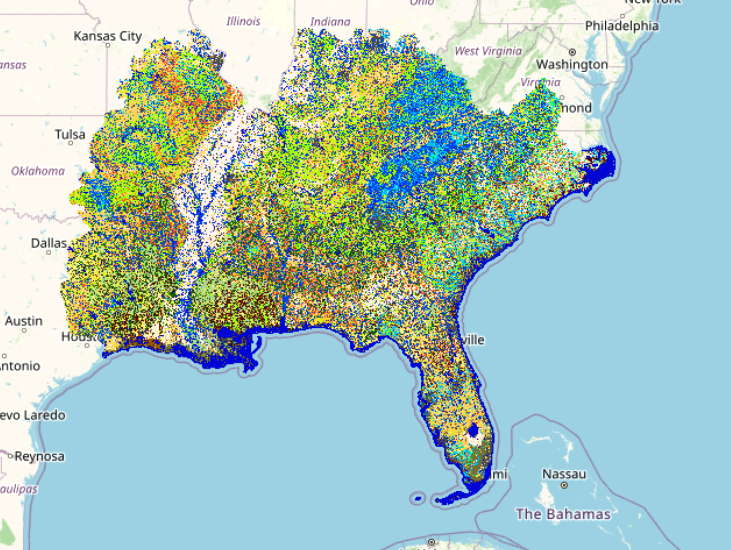 In the Southeast U.S. and other humid summer regions Daily Fuels systematically adjusts surface fuel models (Scott and Burgan 2005) based on daily soil moisture values determined by the Keetch-Byram Drought Index (KBDI, Res. Paper SE-38). The KBDI is a soil moisture deficiency index developed to characterize the impacts of drought on the flammability of surface fuel to better reflect increased fire suppression difficulties under unusually dry conditions.
The Daily Fuels, formerly called Daily MoD-FIS, products are generated automatically every evening in the LANDFIRE Map Viewer during a date range when the daily temperatures, on average, reach above the minimum temperature threshold that can support wildland fire, regardless of drought condition.
Concepts initially developed in the 1988 revisions of the National Fire Danger Rating System (NFDRS) and updated in the NFDRS 2016 version to address severe drought in the Southeast U.S. (NFDRS | NWCG) inform the ruleset used to build these daily maps. Fuel bed characteristics for each NFDRS fuel model along with suggested fuel load additions based on severe drought conditions inform the adjustments. KBDI values are used to proportion the additional available fuel loading into four drought increments or classes that are defined by drought severity (none, low, moderate, high). Formulas that calculate fuel weight in proportion to the fuel time-lag size classes for each fuel load addition and account for fuel bed depth (which increases along with fuel weight) are used to maintain the packing ratio of the fuel model.
To help identify the day-of-year in the map file name, here is a Day-of-Year Calendar.
LF Product Used: LF Fire Behavior Fuel Model 40 (FBFM40)
LANDFIRE MoD-FIS Drought Based Fuel Dynamic (DBFD) system
MoD-FIS poster presented at Missoula Fire Conference
MoD-FIS Comprehensive Plan
Scott and Burgan 2005: Standard Fire Behavior Fuel Models: A Comprehensive Set for Use with Rothermel's Surface Fire Spread Model
LANDFIRE Southeastern Drought Adjusted Surface Fuel Product: Responding to the 2023 Western Gulf Coast Drought
LANDFIRE MoD-FIS Drought Based Fuel Dynamic (DBFD) system
MoD-FIS poster presented at Missoula Fire Conference
MoD-FIS Comprehensive Plan
Scott and Burgan 2005: Standard Fire Behavior Fuel Models: A Comprehensive Set for Use with Rothermel's Surface Fire Spread Model
LANDFIRE Southeastern Drought Adjusted Surface Fuel Product: Responding to the 2023 Western Gulf Coast Drought
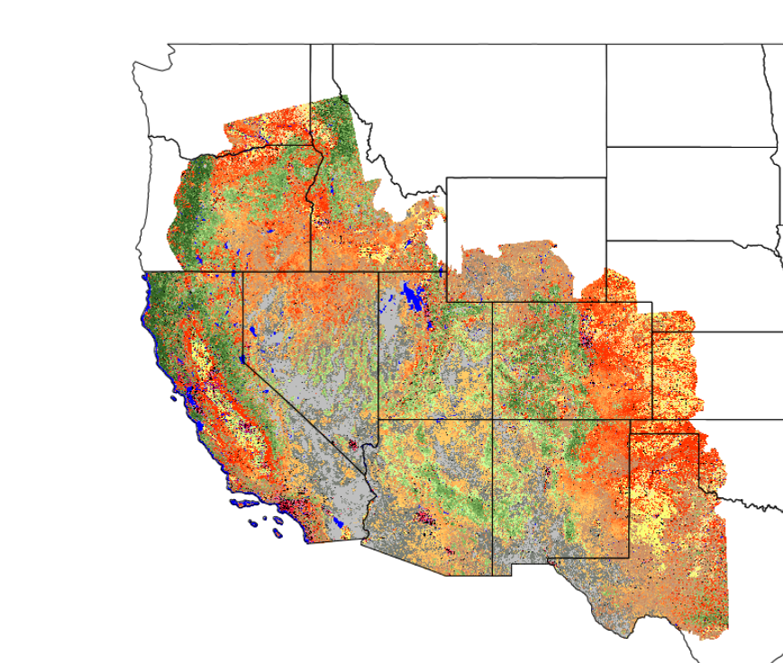 Starting in 2017, Seasonal Fuels, formerly called MoD-FIS, has provided adjusted fuel model (Scott and Burgan 2005) map data in the Great Basin and Southwest regions. Currently, fuel model adjustments are based on Landsat Normalized Difference Vegetation Index (NDVI) values acquired from Harmonized Landsat and Sentinel-2 (HLS) imagery. Because fine fuels, like grasses and shrubs, change rapidly based on seasonal moisture, these updates ensure that fire behavior models reflect more recent landscape conditions rather than outdated static snapshots.
To capture these fluctuations, LANDFIRE produces composited, cloud-free maximum NDVI mosaics (using the 95th percentile) from Harmonized Landsat Sentinel-2 (HLS) imagery across western states four times each fire season. NDVI measures the density of "greenness" on the landscape. High NDVI values indicate lush, live vegetation, while lower values signify "browning" (senescence), dead material, or a lack of vegetation. Every pixel across the region is assigned a specific vegetation "greenness value" and by correlating these satellite observations with existing LANDFIRE herbaceous cover data, we can better quantify the status and abundance of fine fuels in near real-time. Ultimately, these data allow fire managers to adjust/utilize fuel models better suited to current ground conditions.
| Overview Area | Season | Region | Date Range |
|---|---|---|---|
| Early Spring | Southwest | Feb 1 - April 20 |
| Spring | Southwest Northern Great Basin | Feb 1 - May 20 |
| Summer | Southwest Northern Great Basin Northern | Feb 1 - Jun 20 |
| Fall | Southwest | Feb 1 - Sep 20 |
MoD-FIS Comprehensive Plan
GB-SW MoD-FIS White Paper
LANDFIRE Modeling Dynamic Fuels with an Index System Innovations
MoD-FIS Brings Seasonal Fine Fuels Information to Wildland Fire Mangement
Scott and Burgan 2005: Standard Fire Behavior Fuel Models: A Comprehensive Set for Use with Rothermel's Surface Fire Spread Model
MoD-FIS Comprehensive Plan
GB-SW MoD-FIS White Paper
LANDFIRE Modeling Dynamic Fuels with an Index System Innovations
MoD-FIS Brings Seasonal Fine Fuels Information to Wildland Fire Mangement
Scott and Burgan 2005: Standard Fire Behavior Fuel Models: A Comprehensive Set for Use with Rothermel's Surface Fire Spread Model
 Wildfires that burn across hard-baked desert landscapes, such as in southwestern and Great Basin areas of the United States, are driven by fine fuels such as annual/invasive herbaceous. Capturing the seasonal variations in the production of these fuels is what LF’s Seasonal Fuels is about.
Important to fire managers in preparing for a fire season and addressing wildfires as they're happening, Seasonal Fuels provides vital information in understanding when and where those fuels are present, how abundant they are, and how seasonal variation changes over time affects fire behavior.
Seasonal Fuels products (Existing Vegetation Cover, Existing Vegetation Height, and Fire Behavior Fuel Models) are released three times a year, Spring in early June, Summer in early July, and Fall in early October. You can find the MoD-FIS products on the LF Map Viewer, select "Seasonal."
More information about LF's Seasonal Fuels products can be found in the article MoD-FIS Brings Seasonal Fine Fuels Information to Wildland Fire Management.
Wildfires that burn across hard-baked desert landscapes, such as in southwestern and Great Basin areas of the United States, are driven by fine fuels such as annual/invasive herbaceous. Capturing the seasonal variations in the production of these fuels is what LF’s Seasonal Fuels is about.
Important to fire managers in preparing for a fire season and addressing wildfires as they're happening, Seasonal Fuels provides vital information in understanding when and where those fuels are present, how abundant they are, and how seasonal variation changes over time affects fire behavior.
Seasonal Fuels products (Existing Vegetation Cover, Existing Vegetation Height, and Fire Behavior Fuel Models) are released three times a year, Spring in early June, Summer in early July, and Fall in early October. You can find the MoD-FIS products on the LF Map Viewer, select "Seasonal."
More information about LF's Seasonal Fuels products can be found in the article MoD-FIS Brings Seasonal Fine Fuels Information to Wildland Fire Management.
As of January 2026, LANDFIRE products were renamed using only the product, extent, and version names. The unicode (3-digit identifier) and shorthand for the extent were removed. Names were also reworked to be more descriptive and consistent across download platforms.
Examples for products in the version LF 2024 Update at the Conterminous United States (CONUS) extent:
| Product Name | Acronym | New File Name (will be the same across multiple download options - Image Service, Map Viewer, Zip) | Old File Name (where C=CONUS, and 250 or 2.5.0 is the unicode) | New LFPS Layer Name per the LFPS product table | Old LFPS Layer Name |
|---|---|---|---|---|---|
| Existing Vegetation Type | EVT | LF2024_EVT_CONUS | LC24_EVT_250 | LF2024_EVT | 250EVT |
| Final Annual Disturbance | Dist24 | LF2024_Dist24_CONUS | LC24_Dist_250 | LF2024_Dist24 | Dist2024 |
| 40 Scott and Burgan Fire Behavior Models | FBFM40 | LF2024_FBFM40_CONUS | LC24_F40_250 | LF2024_FBFM40 | 250FBFM40 |
The version is named for the most current year of disturbance included. For more information on product versions, see the LANDFIRE Product Versions comparison table.
| Version Name | Disturbance Years | Version Number |
|---|---|---|
| LF 2016 Remap | Includes disturbances for the years 2015-2016 | 2.0.0 (200) = new base map |
| LF 2020 | Includes disturbances for the years 2017-2020 | 2.2.0 (220) = 2nd update to LF 2016 Remap |
| LF 2022 | Includes disturbances for the years 2021-2022 | 2.3.0 (230) = 3rd update to LF 2016 Remap |
| LF 2023 | Includes disturbances for the years 2023 | 2.4.0 (240) = 4th update to LF 2016 Remap |
| LF 2024 | Includes disturbances for the year 2024 | 2.5.0 (250) = 5th update to LF 2016 Remap |
| LF 2025 | Includes disturbances for the year 2025 | 2.6.0 (260) = 6th update to LF 2016 Remap |
OLD CONVENTION Extent shorthand - excluding the Insular Areas
LC L = LANDFIRE C = CONUS
LH L = LANDFIRE H = Hawaii
LA L = LANDFIRE A = Alaska
The history of the "capable" naming convention applicable to LF 2020 and earlier versions
Beginning with LF 2016 Remap, an improvement for fuels products in disturbed areas was implemented. Fuels were adjusted to expected current year vegetation conditions for disturbances that had occurred between certain select years that vary by the version. Making the fuels products "capable to X year fuels" or "capable fuels". Beginning with the LF 2020 Update, Existing Vegetation Cover (EVC) and Height (EVH) were also "capable to X year".
This capability was conveyed by including the capable year in the naming convention. A “capable fuels” download example from LF 2020 (CONUS) would look like:
| Folder name | Geotiff name |
|---|---|
| LF2022_FBFM40_220_CONUS | LC22_F40_220 |
In the LF 2022 Update, and onward, capability is no longer incorporated into the naming convention. This change was implemented to ensure that the products always match the version year and name. Special attention must be paid to the version number (LF 2022 is version number 230) to distinguish it from earlier versions.
A "capable fuels" download example from LF 2022 (CONUS) would look like:
| Folder name | Geotiff name |
|---|---|
| LF2022_FBFM40_230_CONUS | LC22_F40_230 |
Then, beginning with the LF 2022 Update, and onward, capability was no longer incorporated into the naming convention. This change was implemented to ensure that the products always math the version year and name.
Previous LANFIRE Naming Convention for LF 2001 - LF 2004
Disturbance (Dist, FDist, VDist, VTM products)
{AK/US/HI}_{ Official Name, all uppercase }{YYYY} – Product Folder
{Product Folder}\Tif\ {ak/us/hi}_{Official Name, all lowercase}{YYYY}.tif
{Product Folder}\General_Metadata\ {ak/us/hi}_{Official Name, all lowercase}{YYYY}.{xml/htm}
OLD CONVENTION Extent shorthand - excluding the Insular Areas
LC L = LANDFIRE C = CONUS
LH L = LANDFIRE H = Hawaii
LA L = LANDFIRE A = Alaska
The history of the "capable" naming convention applicable to LF 2020 and earlier versions
Beginning with LF 2016 Remap, an improvement for fuels products in disturbed areas was implemented. Fuels were adjusted to expected current year vegetation conditions for disturbances that had occurred between certain select years that vary by the version. Making the fuels products "capable to X year fuels" or "capable fuels". Beginning with the LF 2020 Update, Existing Vegetation Cover (EVC) and Height (EVH) were also "capable to X year".
This capability was conveyed by including the capable year in the naming convention. A “capable fuels” download example from LF 2020 (CONUS) would look like:
| Folder name | Geotiff name |
|---|---|
| LF2022_FBFM40_220_CONUS | LC22_F40_220 |
In the LF 2022 Update, and onward, capability is no longer incorporated into the naming convention. This change was implemented to ensure that the products always match the version year and name. Special attention must be paid to the version number (LF 2022 is version number 230) to distinguish it from earlier versions.
A "capable fuels" download example from LF 2022 (CONUS) would look like:
| Folder name | Geotiff name |
|---|---|
| LF2022_FBFM40_230_CONUS | LC22_F40_230 |
Then, beginning with the LF 2022 Update, and onward, capability was no longer incorporated into the naming convention. This change was implemented to ensure that the products always math the version year and name.
Previous LANFIRE Naming Convention for LF 2001 - LF 2004
Disturbance (Dist, FDist, VDist, VTM products)
{AK/US/HI}_{ Official Name, all uppercase }{YYYY} – Product Folder
{Product Folder}\Tif\ {ak/us/hi}_{Official Name, all lowercase}{YYYY}.tif
{Product Folder}\General_Metadata\ {ak/us/hi}_{Official Name, all lowercase}{YYYY}.{xml/htm}