

The website will be offline from Wednesday the 27th of May 2026 at 8:00 AM to Wednesday the 27th of May 2026 at 12:00 PM. We apologize for any inconvenience this may cause.
A Product Quality Control and Assessment (PQCA) Plan was developed by the PQWT and accepted by the LANDFIRE (LF) Leadership Team and LF Executive Oversight Committee. The plan includes quality control procedures for production processes as well as a product quality assessment approach where applicable. For details of the assessment approach, please download and review the PQCA Plan currently posted for the Western U.S. Milestone.
In short, the LF products quantitatively assessed under the PQCA Plan are those that are modeled directly from geo-referenced field plots contained in the LF Reference Data Base (LFRDB). This includes the Existing Vegetation Type (EVT) and Environmental Site Potential (ESP) products for the Western U.S. Milestone (WUS). For the Eastern U.S. (EUS) and Alaska/Hawaii (AK/HI) Milestones, only the EVT layer is assessed, due to changes in ESP mapping methods. Canopy Fuels and Fire Behavior Fuel Model (FBFM) spatial products are also assessed under the PQCA plan for EUS and WUS, although with different methods than those used for EVT. Canopy Fuels and FBFM were not assessed in AK/HI.
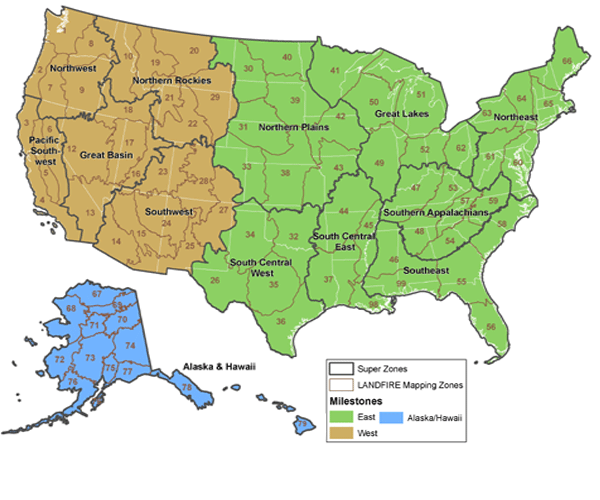
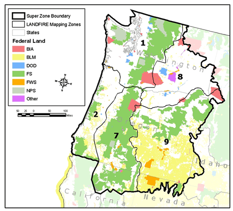
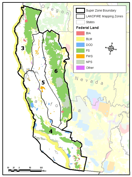
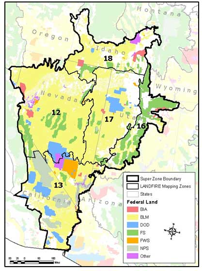
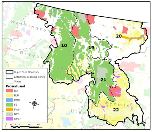
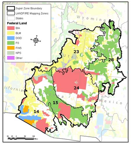
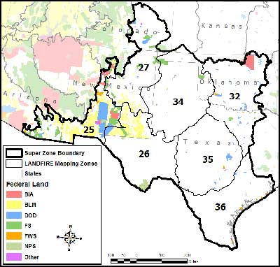
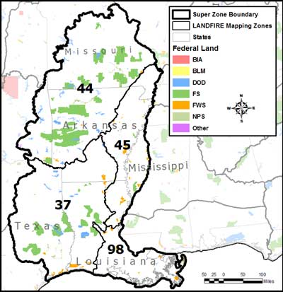
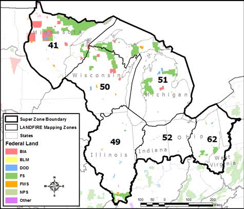
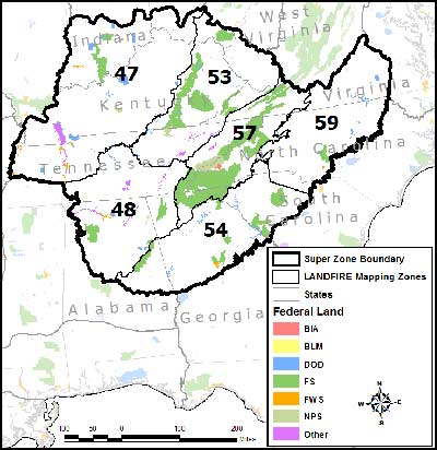
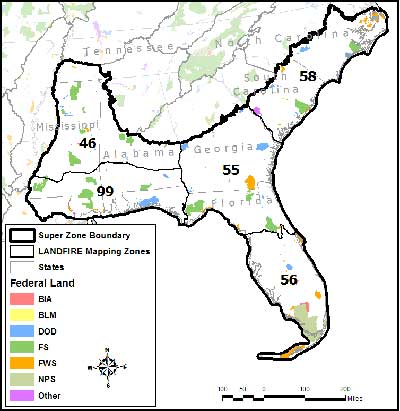
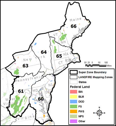
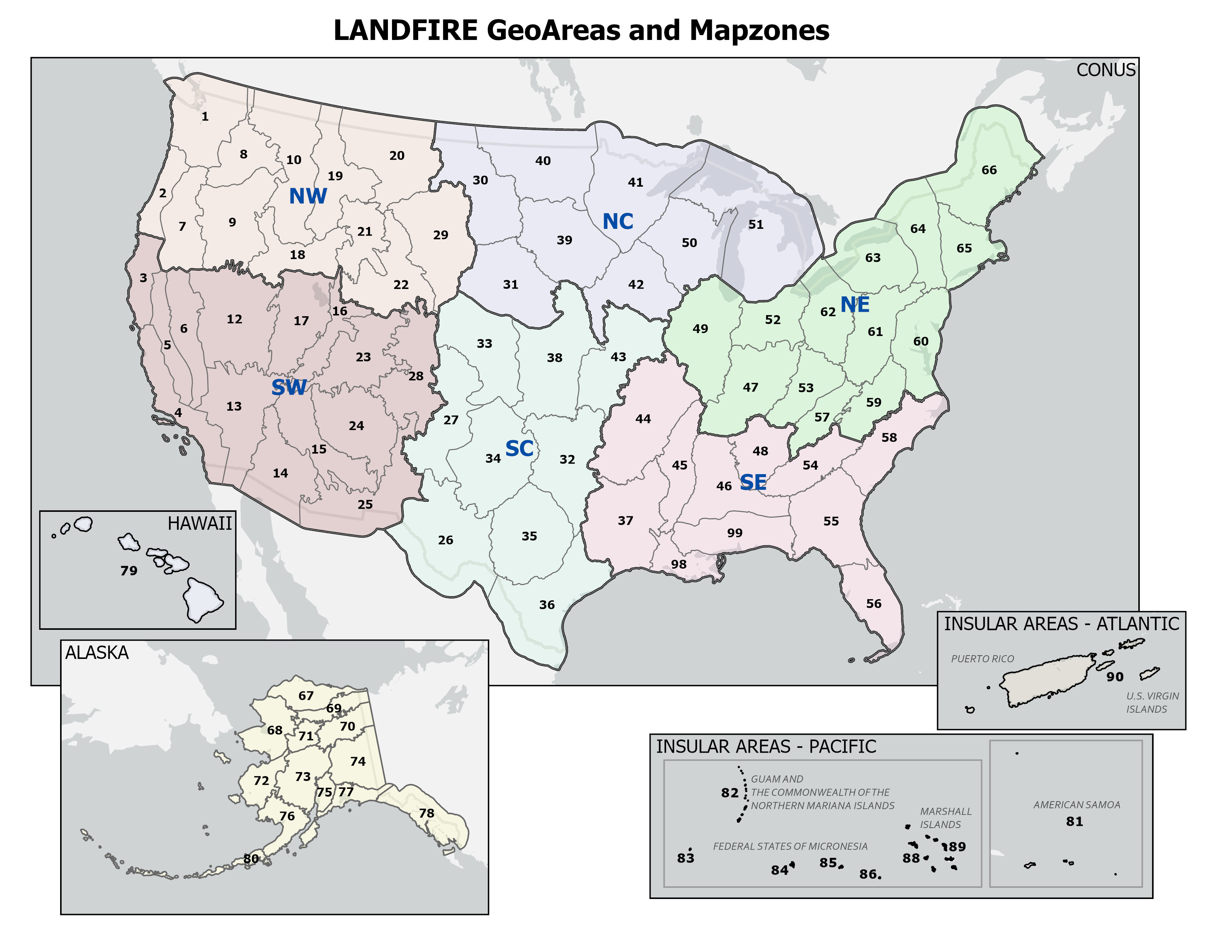
Many of the product quality assessment results are presented by Super Zones, which are aggregations of individual LF mapping zones. Super Zones represent areas with large enough sample sizes to enable meaningful inferences about product quality, given the sampling design used to withhold field plots for product quality assessment. See the PQCA Plan for more detail on the holdout sample design and the use of super zones in the product quality assessment process.
For U.S. mapping zones, results are summarized in six reports as follows:
Eastern U.S.
The LANDFIRE National Eastern Milestone Agreement Assessment Summary presents the overall agreement for the East at a summary level by super zone.
The LANDFIRE National Eastern Milestone Agreement Assessment Super Zone Analysis presents more detailed information about agreement for specific mapped classes within individual super zones in the East.
Western U.S.
The LANDFIRE National Western Milestone Agreement Assessment Summary presents the overall agreement for the West at a summary level by super zone.
The LANDFIRE National Western Milestone Agreement Assessment Super Zone Analysis presents more detailed information about agreement for specific mapped classes within individual super zones in the West.
Alaska/Hawaii
The LANDFIRE National AK/HI Milestone Agreement Assessment Summary presents the overall agreement for Alaska and Hawaii at a summary level by super zone.
The LANDFIRE National AK/HI Milestone Agreement Assessment Super Zone Analysis presents more detailed information about agreement for specific mapped classes within individual super zones in Alaska and Hawaii.
Download contingency tables for this Super Zone.
Download contingency tables for a specific LANDFIRE mapping zone.
Download contingency tables for this Super Zone.
Download contingency tables for a specific LANDFIRE mapping zone.
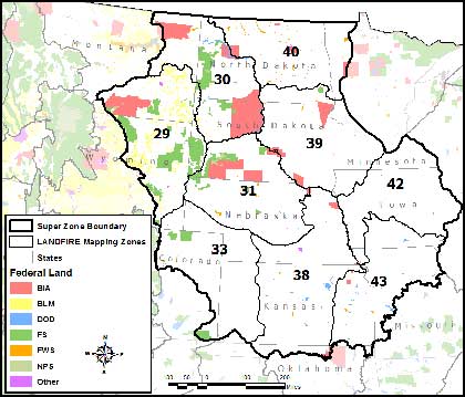
Download contingency tables for this Super Zone.
Download contingency tables for a specific LANDFIRE mapping zone.
Zone 37
Zone 44
Zone 45
Zone 98
Download contingency tables for this Super Zone.
Download contingency tables for a specific LANDFIRE mapping zone.
Zone 37
Zone 44
Zone 45
Zone 98
The PQWT strongly cautions users against using individual map zone results because of sample size and sample distribution issues which severely limit the inferences that can be reliably made from them. They are made available here to provide full disclosure of agreement assessment results, but the PQWT recommends the Super Zone results for most users.
The PQWT strongly cautions users against using individual map zone results because of sample size and sample distribution issues which severely limit the inferences that can be reliably made from them. They are made available here to provide full disclosure of agreement assessment results, but the PQWT recommends the Super Zone results for most users.
Product Description
This page includes a general description of the product, please consult the schedule and version pages for information specific to each release.
LANDFIRE (LF) Annual Disturbance (Dist) products depict where change occurred on the landscape, both spatially and temporally, on an annual basis. These products inform model vegetation transitions to provide updates to LF vegetation, fuel, and fire regime products.
Annual Disturbance products are attributed with disturbance year, type, and severity. These products are applicable in several areas of research and management such as landscape change, habitat gain/loss, carbon stock change, vegetation restoration, and more.
LF 2016 Remap and beyond includes a 90-kilometer buffer along the 1,500 miles of the eastern and southern borders AK shares with Canada. Then with the LF 2020 update, and future updates, for the Conterminous United States (CONUS) a 90-kilometer buffer into Mexico is also included.
Annual Disturbance Products
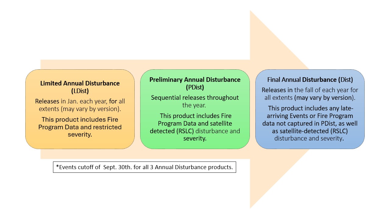
Limited Annual Disturbance
Limited Annual Disturbance (LDist) made its debut with the LF 2023 Update. LDist is designed to provide a first cut of landscape change information as soon as possible to support time-sensitive updates such as risk management efforts. This early release does not include satellite change detection to capture additional disturbances and does not provide image-based severity for contributed events. Some fire program data includes severity which is present in the LANDFIRE LDist product. However, many fires and disturbance events lack severity assignments, therefore LDist severity is a default based on disturbance type (Clearcut = High Severity, Wildfire = Medium Severity, all others including prescribed fire = Low Severity).
LDist includes data inputs from the following sources:
- Fire program perimeters and burn severity where available from four sources: Monitoring Trends in Burn Severity (MTBS), Burned Area Reflectance Classification (BARC), Rapid Assessment of Vegetation Condition after Wildfire (RAVG), Landsat Burned Area (BA)
- Event polygon datasets submitted from two national contributors: US Bureau of Land Management (BLM) and the National Park Service (NPS)
- Event polygon datasets obtained from these online national sources: Forest Service Activity Tracking System (FACTS), National Fire Plan Operations and Reporting System (NFPORS), National Interagency Fire Center (NIFC), USFS National Insect and Disease Risk Map (NIDRM), and Interior Fuels and Post-fire Reporting System (IFPRS)
The LDist product, first featured in the LF 2023 update, is an early "draft" of the LANDFIRE Annual Disturbance product and includes fires, disturbance events, and land management activities for the previous Fiscal Year from trusted national sources obtained in November of the previous calendar year.
Preliminary Annual Disturbance
Preliminary Annual Disturbance (PDist) is another new product making its debut with the LF 2023 Update. PDist is designed to provide a second "draft" of landscape change information and will have multiple extent releases throughout each year:
- Conterminous United States (CONUS) – by GeoArea
- Alaska (AK)
- Hawaii (HI)
- Puerto Rico and the U.S. Virgin Islands (PRVI)
PDist includes disturbance events for the previous Fiscal Year from regional sources obtained in November of the previous calendar year. Additionally, similar to annual disturbance products in past versions, PDist includes results from LANDFIRE satellite change detection and image-based severity. A complete list of data contributors can be found here: LANDFIRE Program: Contribute Data - Previous Contributions.
The PDist product featured in the current version will be used to update the Vegetation and Fuel (including Fuel Disturbance) products included in releases throughout the rest of the year.
Annual Disturbance
The Final Annual Disturbance (Dist) product is the "final" draft of Annual Disturbance data for a given version. Compared to PDist, Dist includes additional fires and disturbance events for the previous Fiscal Year, these events were harvested from a second "pull" of the national online sources in the summer of the current calendar year.
- The Public Events Geodatabase for the current version is always released in the fall, and includes events captured from this second "pull".
- The events harvested from the second "pull" will not be incorporated into the production of Fuel Disturbance (FDist) and other Fuel, Vegetation, and Fire Regime products. These events will be included in the next version.
Annual Disturbance Resources
CONUS Limited Disturbance (LDist) All Years
Alaska Limited Disturbance (LDist) All Years
Hawaii Limited Disturbance (LDist) All Years
IA/Puerto Rico/Virgin Islands Limited Disturbance (LDist) All Years
CONUS Preliminary Disturbance (PDist) All Years
Alaska Preliminary Disturbance (PDist) All Years
Hawaii Preliminary Disturbance (PDist) All Years
IA/Puerto Rico/Virgin Islands Preliminary Disturbance (PDist) All Years
CONUS Disturbance All Years
Alaska Disturbance All Years
Hawaii Disturbance All Years
IA/Puerto Rico/Virgin Islands Disturbance All Years
Addressing Hurricane Helene's Disturbance: A Customized Mapping and Data Integration Solution
LANDFIRE's NEW Disturbance Products (and Severity Data) Explained
A day in the life of a LANDFIRE Disturbance Mapper
The Spatially Adaptable Filter for Error Reduction (SAFER) Process: Remote Sensing-Based LANDFIRE Disturbance Mapping Updates
Methods used to mitigate data gaps in LF 2012 and beyond.
A LANDFIRE Disturbance explained
Annual Nationwide Remote Sensing of Disturbance for LANDFIRE (2021)
Mapping Disturbance for the Conterminous United States in Less than Six Months: Exploring Improvements in Processing Power, Image Compositing, and Improved Change Detection Algorithms
Keeping LANDFIRE Data Current – It's a Matter of Disturbance
Monitoring Trends in Burn Severity
Product Details
The Disturbance and Treatment Polygons (Events) is a collection of natural disturbance and land management activities used to determine disturbance causality in LF products and can be used in change detection analysis. Disturbance and Treatment Polygons (Events) contains over 2.4 million polygons from 1999-2024 across the United States and U.S. territories.
The Disturbance and Treatment Polygons (Events) includes contributions from:
- Federal
- State
- Local
- Private Organizations
Disturbance and Treatment Polygons (Events) include a feature dataset for Alaska (AK), CONUS, Hawaii (HI), and the island territories of Federated States of Micronesia (FSM), Guam/Northern Mariana (GUCNMI), Palau, and Puerto Rico.
Each feature dataset contains two feature classes, namely Raw Events and Model Ready Events. The Public Raw and Model Ready Event feature classes include disturbance and vegetation/fuel treatment data.
In addition to the feature classes there is also a look up table for the source code, which is an attribute in all feature classes. The source code is a LANDFIRE internal code assigned to each data source. Please consult the Look Up Table link for more information about the data sources included and excluded from this release.
Look Up Table
Certain proprietary and/or sensitive data were removed in this public geodatabase. The lutSource_Code is a table which is an attribute in all three feature classes. Consult the table "lutSource_Code" for more information about the data sources.
The data in the Public Raw Events feature class have been analyzed to eliminate geospatial or information content errors but otherwise represent the full account of acceptable data processed for LANDFIRE. These data may include multiple perimeters for the same event and a high degree of overlap between events within a single calendar year or fiscal year. Examples of the former include the same management activity or disturbance event reported by multiple agencies or individuals. Examples of the latter include locations in which multiple management activities and/or disturbances occurred within the same calendar year or fiscal year.
The data in the Public Raw Events feature class have been analyzed to eliminate geospatial or information content errors but otherwise represent the full account of acceptable data processed for LANDFIRE. These data may include multiple perimeters for the same event and a high degree of overlap between events within a single calendar year or fiscal year. Examples of the former include the same management activity or disturbance event reported by multiple agencies or individuals. Examples of the latter include locations in which multiple management activities and/or disturbances occurred within the same calendar year or fiscal year.
The Public Model Ready Events feature class has been reduced to only one unique event per calendar year per location for data from 1999-2020 and one unique event per fiscal year per location for data from 2021-2024. To produce the Model Ready layer, a series of topologies were created with the Raw Events data to identify areas of overlap between polygons within the same calendar or fiscal year.
A standard hierarchy of LANDFIRE event types was applied to correct the topology errors. For more specifics on the rankings download the LANDFIRE_Public_Events_README.pdf and review Appendix B.
Appendix B
LANDFIRE Event Type Nomenclature and Hierarchy
Event Types at the top of this list are highest ranked events thus having the greatest impact on vegetation/fuel composition
Hierarchy for data from 1999-2023
| LANDFIRE Event Type |
|---|
| Development |
| Clearcut |
| Harvest |
| Thinning |
| Mastication |
| Other Mechanical |
| Wildfire |
| Wildland Fire Use |
| Prescribed Fire |
| Wildland Fire |
| Weather |
| Insecticide |
| Chemical |
| Insects |
| Disease |
| Insects/Disease |
| Herbicide |
| Biological |
| Planting |
| Reforestation |
| Seeding |
Hierarchy for data from 2024
| LANDFIRE Event Type |
|---|
| Development |
| Clearcut |
| Harvest |
| Thinning |
| Mastication |
| Mechanical Add |
| Mechanical Remove |
| Mechanical Unknown |
| Wildfire |
| Wildland Fire Use |
| Prescribed Fire |
| Weather |
| Insecticide |
| Chemical |
| Insects |
| Disease |
| Insects/Disease |
| Herbicide |
| Biological |
| Planting |
| Reforestation |
| Seeding |
A selected perimeter may not necessarily be from a public data set so the Public Model Ready Events feature class may be missing information on events that appear in the Public Raw Events feature class. The result is a layer which contains only one event per calendar year for a location for data from 1999-2020. Data from 2021-2024 contains only one event per fiscal year for a location. Point derived polygons and polygons that were <0.02 acres are also removed from the Public Model Ready Events
Improvements
LANDFIRE is no longer producing the exotics polygon layer, and it is no longer included in the Disturbance and Treatment Polygons (Events). You can still access the LF 2023 Exotics polygon data which includes Exotics data from 1999-2023 on the LF Map Viewer.
Beginning with the LF 2022 Update, LANDFIRE started re-collecting disturbance and treatment polygons June 1 each year from online National data sources. These sources include Forest Service Activity Tracking System (FACTS), National Interagency Fire Center (NIFC), USFS National Insect and Disease Risk Map (NIDRM), and Interior Fuels and Post-Fire Reporting System (IFPRS). Updated data is pulled from these sources and any new treatments or disturbances are added. For LF 2022, LANDFIRE added 6.5 million acres of disturbance and treatment polygon events data to the LF Public Raw Events product upon re-collection. For a grand total of ~28 million acres of Raw Events data featured within the LF 2022 Update.
Disturbance Data Processing - learn how LF evaluates and processes the Disturbance and Treatment Polygons (Events)
Disturbance Data Processing - learn how LF evaluates and processes the Disturbance and Treatment Polygons (Events)
Brenda Lundberg
LANDFIRE Reference Data Administrator
blundberg@contractor.usgs.gov
Brenda Lundberg
LANDFIRE Reference Data Administrator
blundberg@contractor.usgs.gov
Select your GeoArea of interest from the list below to download the LF 2016 Public version of the LF Reference Database.
1. This database includes a subset of the full suite of field-referenced data that was used in the production of LF National and LF 2016 Remap deliverables. According to agreements between LF and its data contributors, certain proprietary or otherwise sensitive data have been removed to create this publicly available version of the database. Please consult the table lutdtVisitsSourceID in this database for more information about the datasets included in, and excluded from, this release. The data in this public version is the extent of information that you have permission to use. These data are being provided for the purposes that the web site describing this database was intended.
2. These data are provided "as-is" and without express or implied warranties as to their completeness, accuracy, suitability, or current state thereof for any specific purpose. No agent of LF shall have liability or responsibility to data users or any other person or entity with respect to any loss or damage caused or alleged to be caused directly or indirectly by the dataset. These data and related graphics (such as ".gif" or ".jpg" file formats) are not legal documents and are not intended to be used as such. Users take full responsibility for their applications of these data.
3. LF is not obligated to provide updates to the data herein, as they are and shall remain consistent with those used to develop the LF National and LF Remap products. However, the LF Program will, at its discretion, continue using these and other field-sampled data to update and improve future versions of LF products. Users of these data are requested to inform the LF Program of significant errors to assist with product maintenance activities. Please send your feedback to helpdesk@usgs.gov.
GeoAreas
A public version of the LANDFIRE (LF) 2016 Remap Reference Database (LFRDB) is available. The LFRDB contains a subset of the data and attributes used for LF National and LF Remap production. The Public LFRDB includes vegetation and fuel data that were largely amassed from existing information resources such as:
- USFS Vegetation and Fuel Plot Data
- USGS National Gap Analysis Program (GAP)
- NPS Inventory and Monitoring (I&M)
- State Inventory Data
Updated plot information was compiled for LF Remap and used to inform existing vegetation mapping. This new data was added to the public LFRDB for LF Remap.
Note: The latest LFRDB is LF 2016 Remap.
Data archived in the LF Remap Public LFRDB include:
| Vegetation | Fuel |
| natural community occurrences estimates of canopy cover and height per plant taxon measurements of individual trees occurrence of exotics plants | biomass estimates of downed woody material depth or biomass estimates of litter and duff layers percentage cover and height of shrub and herb layers |
Major Public LFRDB attributes derived from the sampling data include:
- Ecological System and NVCS Group labels
- Lifeform cover and height estimates
- Predictor data extracted from ancillary data layers and used for mapping
Certain proprietary and/or sensitive data were removed in the public database. Consult the table lutdtVisitsSourceID in the database regarding data sources.
The Public LFRDB can be used as input to spatial and non-spatial vegetation models and is applicable for ground truthing and accuracy assessments for a variety of modeling and mapping efforts.
Public LANDFIRE Reference Database Resources
LFRDB EVT Assignment Evaluation
Developing Auto-Keys for LANDFIRE Vegetation Mapping: 2014-2015 CONUS Project Report
Open Office Hours: Listen to LF Reference specialist, Brenda Lundberg, talk about the LFRDB.
LFRDB EVT Assignment Evaluation
Developing Auto-Keys for LANDFIRE Vegetation Mapping: 2014-2015 CONUS Project Report
Open Office Hours: Listen to LF Reference specialist, Brenda Lundberg, talk about the LFRDB.
LANDFIRE Technical Documentation
A detailed description of the processes that went into the LF 2016 Remap effort and the methods for creating each LF product.
View Document
LANDFIRE Dictionary
A “one-stop shop” general resource that provides information about products, Attribute Data Dictionaries (ADDs), data and metadata, and terms.
View Document
LF Definitions, Quality, and Standards
Provides information about contributors, metadata and data standards, data creation, and data testing. This document also provides details about our general data release process.
View Document
LANDFIRE Research Review
LANDFIRE welcomes researchers to share work that incorporates LANDFIRE Program Products for a friendly, informal review—at any stage of development.
Learn More
2026
Utah Wildfire Risk Assessment and High Risk WUI [Journal Article]
2025
Changing fire regimes in the Great Basin USA [Journal Article]
Quantifying the Representation of Plant Communities in the Protected Areas of the U.S.: An Analysis Based on the U.S. National Vegetation Classification Groups [Journal Article]
Spatial Scale Dependence of Error in Fractional Component Cover Maps - ScienceDirect [Journal Article]
An Interagency Perspective on Improving Consistency and Transparency of Land Use and Land Cover Mapping [Journal Article]
2024
Modelling and mapping burn severity of prescribed and wildfires across the southeastern United States (2000-2022) [Journal Article]
Connected Science: Twenty years of science and management with LANDFIRE [Publication]
Missoula Fire Lab Seminar Series: A New Foundation for LANDFIRE [Video]
2023
A Multimodal Data Fusion and Deep Learning Framework for Large-Scale Wildfire Surface Fuel Mapping [Journal Article]
LANDFIRE: Foundational data used to support Cohesive Strategy Goals [Video]
Hawaii_Wildfires_LANDFIRE_Wildfire_Risk_to_Communities_2023 [Publication]
Prototyping an improved LANDFIRE base product via state-of-the-art data preprocessing and modeling techniques [Publication]
Longleaf Pine Sustainability Analysis Technical Report [Technical Report]
Landsat-Scale Regional Forest Canopy Height Mapping using ICEASat-2 Along-track heights: case study of eastern texas [Journal Article]
Using social media data and machine learning to map recreational ecosystem services [Journal Article]
Contemporary wildfires are more severe compared to the historical reference period in western US dry conifer forests. [Application Summary]
USGS Wildfire Hazard and Risk Assessment Clearinghouse [Application]
LANDFIRE and Certified Sustainable Forest Management [Application Summary]
Regional Stem Volume Mapping: A Feasibility Assessment of Scaling Tree-Level Estimates [Journal Article]
2022
Locating potential historical fire-maintained grasslands of the eastern United States based on topography and wind speed [Journal Article]
TreeMap 2016 Dataset Generates CONUS-Wide Maps of Forest Characteristics Including Live Basal Area, Aboveground Carbon, and Number of Trees per Acre [Journal Article]
Construction of Probabilistic Wildfire Risk Estimates for Individual Real Estate Parcels for the Contiguous United States [Journal Article]
Behavioral states in space and time: understanding landscape use by an invasive mammal [Journal Article]
Green Mountain National Forest historical fire regime assessment LANDFIRE [Application Summary]
Climate Land Cover (LANDFIRE Derived) - Datasets - California Natural Resources Agency Open Data [Journal Article]
LCMAP Change Stories: Sequoias under Siege, Progression of a Wildfire [Application Summary]
Scientists use AI to update data vegetation maps for improved wildfire forecasts [Journal Article]
Mapping the wildland-urban interface in California using remote sensing data [Journal Article]
Impacts of Agricultural Management Systems on Biodiversity and Ecosystem Services in Highly Simplified Dryland Landscapes [Journal Article]
LANDFIRE Data and Applications [Fact Sheet]
A Short Tour of the Interagency Fuel Treatment Decision Support System (IFTDSS) [Journal Article]
2021
LF & Forest Inventory and Analysis (FIA) - 15 Years of Growing Research and Partnerships
New Eastern Region Wildfire Risk Assessment [Project Report]
Development and Application of the Fireshed Registry [Project Report]
The importance of small fires for wildfire hazard in urbanised landscapes of the northeastern US [Journal Article]
Mapping regional forest management units: a road-based framework in Southeastern Coastal Plain and Piedmont [Journal Article]
2020
Drought Sensitivity and Trends of Riparian Vegetation Vigor in Nevada, USA (1985–2018) [Journal Article]
LF Foundational Publications:
LF Total Fuel Change Tool (LFTFC) - Facilitates editing LF rule sets to create customized surface and canopy fuel layers for local applications.
Wildfire Risk to Communities - website with interactive maps, charts, and resources to help communities understand, explore, and reduce wildfire risk.
State-and-transition simulation (ST-Sim) - Fully integrated spatially explicit simulation capabilities with the ability to include input rasters in GeoTIFF format for initial state classes, strata and ages and the ability to output rasters for these same variables as well as transitions and time since transition.
Compare fuel models spreadsheet-Joe Scott - allows a user to make quick, simple comparisons of the new fuel models with each other and with the original 13 fuel models
Updated - Compare fuel models spreadsheet-Joe Scott - Users can add custom fuel models to the list in the CompareModelsFour spreadsheet.
Landscape GeoTIFF File - a multi-band raster format, is commonly used by wildland fire behavior and fire effects models such as FARSITE and FlamMap.
BLM - Bodie Hills Conservation Action Planning
Data Comparison and Sensitivity Analysis in Yellowstone National Park
LANDFIRE 2008 data in the Cowychee Mountain Community Wildfire Protection Plan, Yakima, Washington — Making Risk Assessments User-Friendly
Modeling Alternative Scenarios of Land Cover Change and Conservation Outcomes in the Forest of the Northern Great Lakes Region Using LANDFIRE Data Products
Modeling Grizzly Bear Density using LANDFIRE Data Products
Upper Fraser Valley CWPP and LANDFIRE data: Northern Colorado
Use of LANDFIRE Data in Bee Pollination Study
Use of LANDFIRE Data in Bighorn Sheep Viability Analysis: Payette National Forest Area Use of LANDFIRE data in fuels program prioritization and planning: Signal Peak Assessment
Use of LANDFIRE Data in Wildland Fire Risk Assessment and Multi‐Year Fuels Program Planning for Bureau of Indian Affairs, Spokane Agency, and Spokane Tribe – June 2008
Use of LANDFIRE Data in Wildland Fire Risk Assessment: Ashley Lakes Fire
Use of LANDFIRE Data Products on Fire Incidents in 2007
Use of LANDFIRE in Sage-Grouse Habitat Analysis: Western North America
Use of LANDFIRE Vegetation Dynamics Models and FRCC* Maps to Support Ecological Assessments and Forest Plan Revisions in the Southwest Region
Yellowstone Central Plateau Fire Behavior Assessment using LANDFIRE data products: 2007
Aboveground live carbon stock changes of California wildland ecosystems, 2001–2010
Beyond Fuel Treatment Effectiveness: Characterizing Interactions between Fire and Treatments in the US GeoArea