Reference products were input for the LANDFIRE (LF) Update process by providing cause of change on the landscape, as well as being useful for LF's ongoing remap efforts. Public versions of LF reference database, which exclude proprietary and/or sensitive data, are available for download.

Public Reference Database (LFRDB)

Consists of vegetation and fuel data from geo-referenced sampling units nationwide.

Contribute Data

Disturbance and Treatment Polygons (Events)

A collection of recent natural disturbance and land management activities used to update existing vegetation and fuel layers.

Version Comparison Table

Version NameTypeYear(s) of Annual Disturbance products in the versionDescriptionCompletion YearStatus
LF 2025Update2025Includes vegetation transition rules for 2025 disturbances and fuels transition rules for 2016-2025 disturbances.2026 
LF 2024Update2024Includes vegetation transition rules for 2024 disturbances and fuels transition rules for 2015-2024 disturbances.2025 
LF 2023Update2023Includes machine-learning modeled vegetation within 2003-2023 disturbances and fuels transition rules for 2014-2023 disturbances.2024 
LF 2022Update2021-2022Includes vegetation transition rules for 2017-2022 disturbances and fuel transition rules for 2013-2022 disturbances.2023 
LF 2020Update2017-2020Includes vegetation transition rules for 2017-2020 disturbances and fuel transition rules for 2012-2020 disturbances.2023Archived
LF 2019 LimitedLimited Update2017-2019Includes vegetation transition rules for limited 2017-2019 disturbances and fuel transition rules for 2011-2019 disturbances.2021Archived - Superseded by LF 2020
LF 2016 RemapNew Base Map2015-2016Includes modeled vegetation for all pixels and fuel transition rules for 2010-2016 disturbances.2021 
LF 2014Update2013-2014Includes vegetation and fuel transition rules for 2005-2014 disturbances.2017Archived
LF 2012Update2011-2012Includes vegetation and fuel transition rules for 2003-2012 disturbances.2015Archived
LF 2010Update2009-2010Includes vegetation and fuel transition rules for 2001-2010 disturbances.2013Archived
LF 2001Base Map1999-2007LANDFIRE National Base Map Refresh, an enhanced and “version 2” of the LF National Base Map. Comprehensive vegetation and fuels mapping reflects circa 2001 using circa 2001 imagery. Captures 1999-2007 disturbances.2011Archived
► LF 2008Update1999-2008Includes vegetation and fuel transition rules for 1999-2008 disturbances.2011Archived

The OpenGIS® Web Map Service Interface Standard (WMS) is an HTTP interface for requesting and serving geospatial map images over the internet. A WMS request defines the geographic layer(s) and area of interest to be processed and serves, or responds, with one or more geospatial map images that are able to be displayed in a browser application. A WMS call allows you to access and view LF data within your desktop mapping session that are formatted as they appear on the LF Map Viewer (formerly DDS).

Web Coverage Service (WCS) is also an HTTP interface that provides an open specification for sharing datasets on the web. WCS allows you to access LF products for analysis or modeling without downloading data. WCS provides the pixel value of the data.

  • Hawaii only: The provided WCS URLs will work with ESRI tools. QGIS and other non-ESRI products will be unable to use the WCS URL to view the Hawaii LF data as it is projected in ESRI 102007. Users can use non-ESRI products to view downloaded LF data from the map viewer or mosaic download.


WMS and WCS URLs

To use the WCS URL in ArcMap or ArcPro, use the bare URLs provided below.

To use the WCS URL in a web browser, append: ?request=GetCapabilities&service=WCS onto the end of the WCS URL.


The searchable table below is a condensed version of the data contributions. To search the complete list of data contributions, download the entire Compiled Data Table.

Note: CONUS-wide datasets are available by typing "CONUS" in the "Search" box.

Prior to 2015 many data sources were reported by state or region. Starting in 2015, federal and nationwide datasets were often consolidated into one source. If you suspect your local dataset may have been one of the sources merged into a larger dataset, type "nationwide" in the "State/Region" field. The resulting information should help you determine if your data was used in LANDFIRE.

Product Description

Vegetation Condition Class (VCC) represents a simple categorization of the associated Vegetation Departure (VDep) and is a derivative of the VDep layer. It indicates the general level to which current vegetation is different from the estimated modeled vegetation based on past reference conditions. VDep and VCC are based upon methods originally described in the Interagency Fire Regime Condition Class Guidebook, but are not identical to those methods and should not be considered as a replacement data set. Full descriptions of the methods used can be found in the VDep product description. Note that the LANDFIRE (LF) team feels it is very important for users to review the VDep methods before comparing VDep or VCC values across LF versions.

VCC is not always created for all extents and/or all versions of LF. See the schedule page to learn more about each version.

In LF 2012, the original three VCC classes were divided in half to create six VCC classes to provide additional thematic resolution. The below table describes the classes:

LF 2012 and forwardLF c2001 National, LF 2001, LF 2008
VCC I.A: Very Low, VDep 0 - 16VCC I: Low departure, VDep 0 - 33
VCC I.B: Low, VDep 17 - 33
VCC II.A: Moderate to Low, VDep 34 - 50VCC II: Moderate departure, VDep 34 - 66
VCC II.B: Moderate to High, VDep 51 - 66
VCC III.A: High, VDep 67 - 83VCC III: High departure, VDep 67 - 100
VCC III.B: Very High, VDep 84 - 100

The six new VCC classes can be collapsed into the original three VCC classes as shown above. Both the original three and new six class VCC classifications are included as attributes in the LF 2012 and beyond VCC layer.


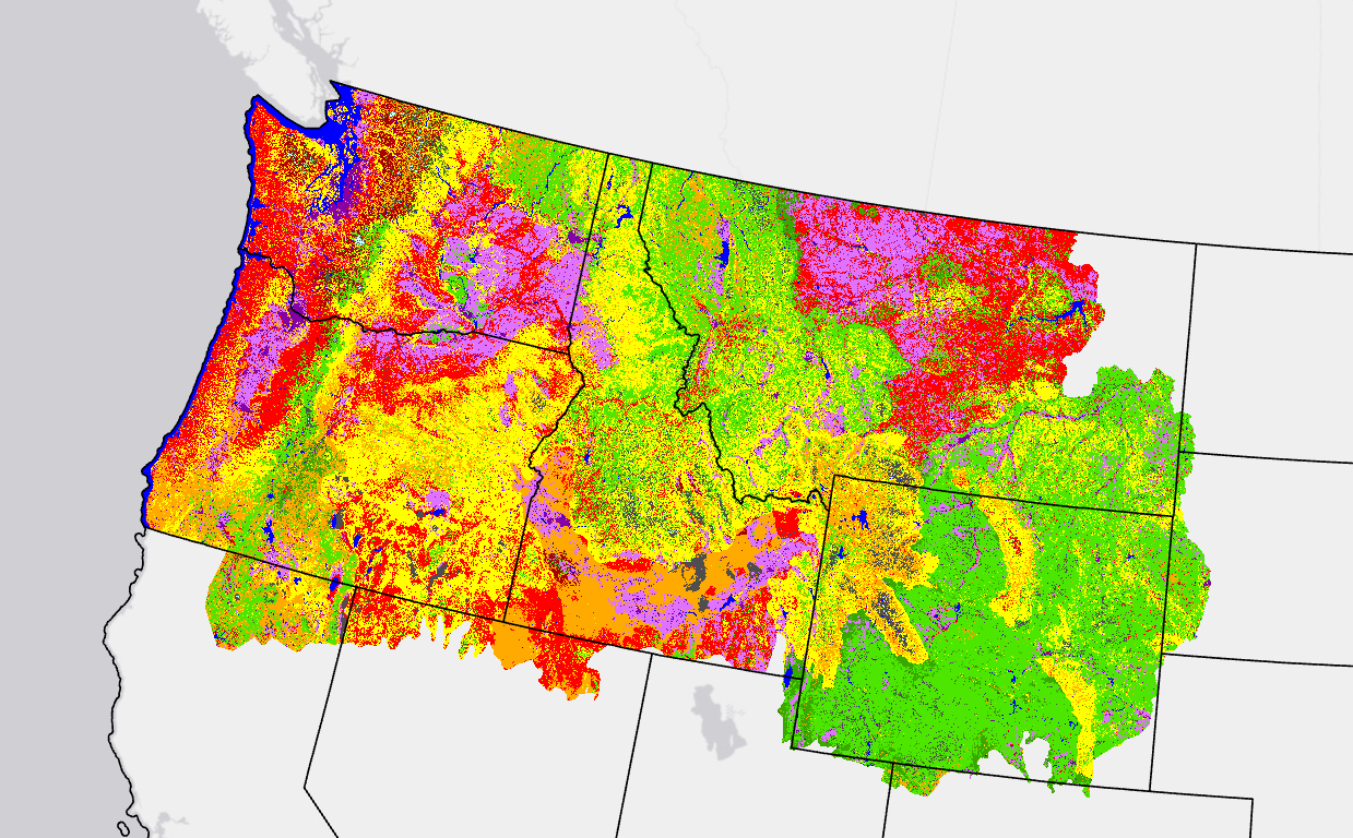
Image of the upper NW corner of the U.S. with colors of VCC on the map.
FAQs

LANDFIRE (LF) never delivered a "full" FRCC product as originally described, even when the product carried that name, so it was renamed to reduce confusion.

FRCC is composed of two elements: Vegetation Departure and Fire Regime Departure. LF produced and delivered the first component of FRCC (Vegetation Departure) because LF had no consistent way to estimate Fire Regime Departure over the entire geography. Therefore, the product was renamed VCC since it is a more appropriate and descriptive name. VCC is just the current VDep product sliced into categories.

Summary units for vegetation departure calculations varied across the LANDFIRE versions and are specified on the Vegetation Departure web page.
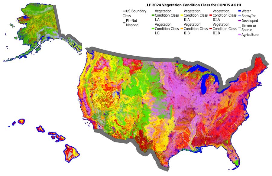
Flyout map of color-coded LF2024 models for vegetation condition classes for CONUS, AK and HI
Map showing color-coded LF2024 Vegetation Condition Class models for CONUS, Alaska and Hawaii

Vegetation Condition Class Resources

Contribute Your Data to LANDFIRE

LANDFIRE would like to acknowledge and thank everyone who has contributed data. We rely on high-quality disturbance, treatment, vegetation, and fuel data from agencies and partners to maintain accurate landscape products. User contributions help ensure we can produce reliable annual updates.
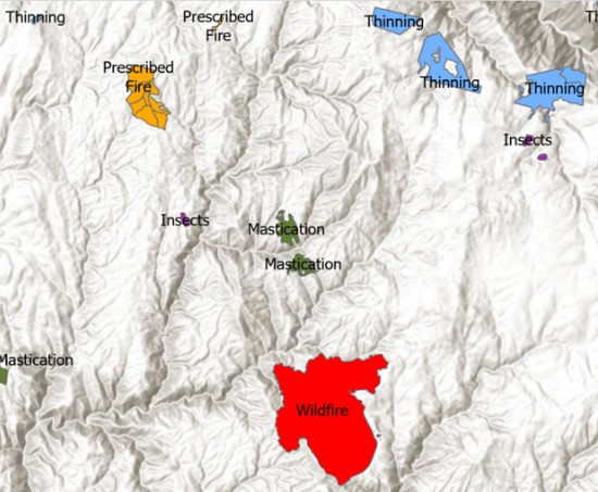
Map showing polygons for disturbance and treatment areas

Contribute Your Disturbance & Treatment Polygons

Disturbance and treatment polygons (also known as events) are a top priority for annual updates and are stored in the LF Disturbance and Treatment Polygon Geodatabase (formerly known as the Events Geodatabase). Refer to the LANDFIRE Data Collection Requirements for required attributes. LF processes data by fiscal year and requires that the disturbance/treatment date or federal fiscal year be included with all data submissions.

Collection Dates: October 1st (previous year) through September 30th (current year).

Deadline to Submit: All submissions must be in partner systems or emailed to LANDFIRE by October 31st.

Database Pulls: LF always pulls data from USDA Forest Service Activity Tracking System (FACTS), Interior Fuels & Post-fire Reporting System (IFPRS), National Interagency Fire Center (NIFC)/(InFORM), and USFS Insect/Disease. The Contributing Agency Database, linked below in Supplemental Resources, lists other websites or agency databases that LF has collected data from. If your dataset is listed in the database, confirm it has been updated and submitted prior to the September 30th deadline every year.

Data Format: We accept data in various formats including map services, ESRI shapefiles, geodatabases, and ArcInfo coverages. Supporting information, including definitions of the fields and any codes in the data tables, should accompany the data to ensure correct interpretation.

Submit Data Directly to LANDFIRE: All data should be submitted to Brenda Lundberg, LANDFIRE Reference Data Administrator at blundberg@contractor.usgs.gov.

Current Data Call Letter For LF 2026

Check out LF Contributed Data Table to search all past data contributors!

State Contributors

LANDFIRE relies on state and local data to help fill holes and create the best products possible. While LF may receive some data through federal databases, we are also looking for state treatment and disturbance data.

LANDFIRE is now collaborating with the National Fuels Treatment Database (NFT) and State treatment data and polygons will be gathered from their comprehensive database. LANDFIRE is striving to reduce reporting demands for state-level GIS, forest, and fire managers to create a more efficient reporting process.

The map below shows the states where state agencies did and did not submit disturbance and treatment data for LF 2025. If your state is colored purple, it indicates that LF received disturbance and treatment data from your state agencies, with the contributed polygons shown. All states colored orange, show where LF can use state contributed data! Map does not show contributions from NIFC/InFORM or Federal Agencies.
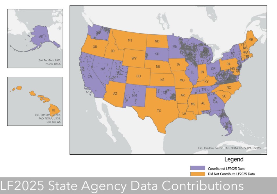
Map showing dots by state for LF 2024 data contributions

Your Disturbance and Treatment Polygons at Work

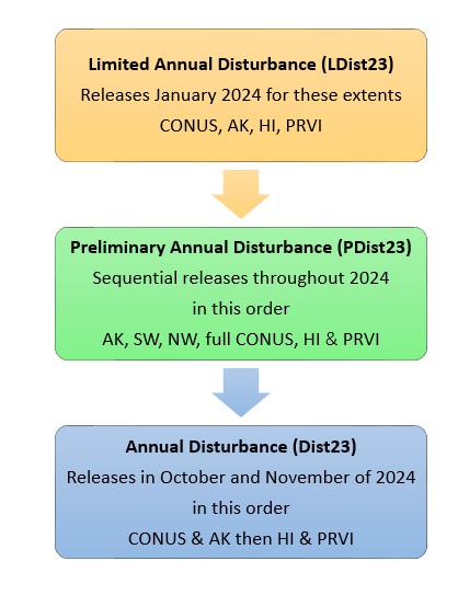
So, you submitted your data and you want to know when it will show up. LANDFIRE creates and releases an early, Limited Annual Disturbance (LDist) product that uses only National federal events including FACTS, IFPRS, NIFC, USFS Insect/Disease. We also get National data submissions from the Bureau of Land Management (BLM) and the National Park Service (NPS).

The Preliminary Annual Disturbance (PDist) product is sequentially released with each Geographic Area. All submitted state and local disturbance and treatment polygons collected by the October 31st deadline are included in the PDist product and are what feeds into the Vegetation and Fuels products.

A final pull from Federal databases is done early June, with these events being added to the Final Annual Disturbance (Dist) product. Final Annual Disturbances will only influence Vegetation and Fuels products for the next years’ products.
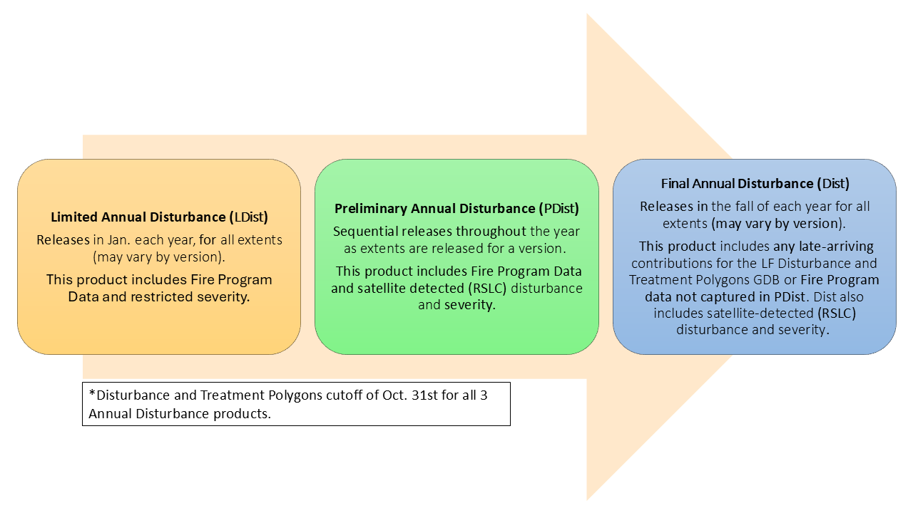
Flowchart showing process of contributing disturbance data
 

Other Data We Collect

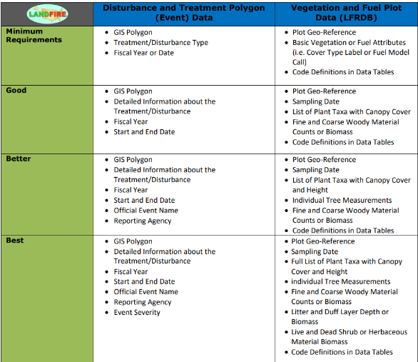
Good, Better, Best Data Collection Requirements

Linked below is a downloadable document showing all the attributes LANDFIRE requires, and optional data that we would love to receive with the data that is submitted for Disturbance and Treatment Polygons, and Vegetation and Fuel Plot data. You can download the document here.

Data table showing levels of quality for event, plot and feedback data

FAQs

Resources

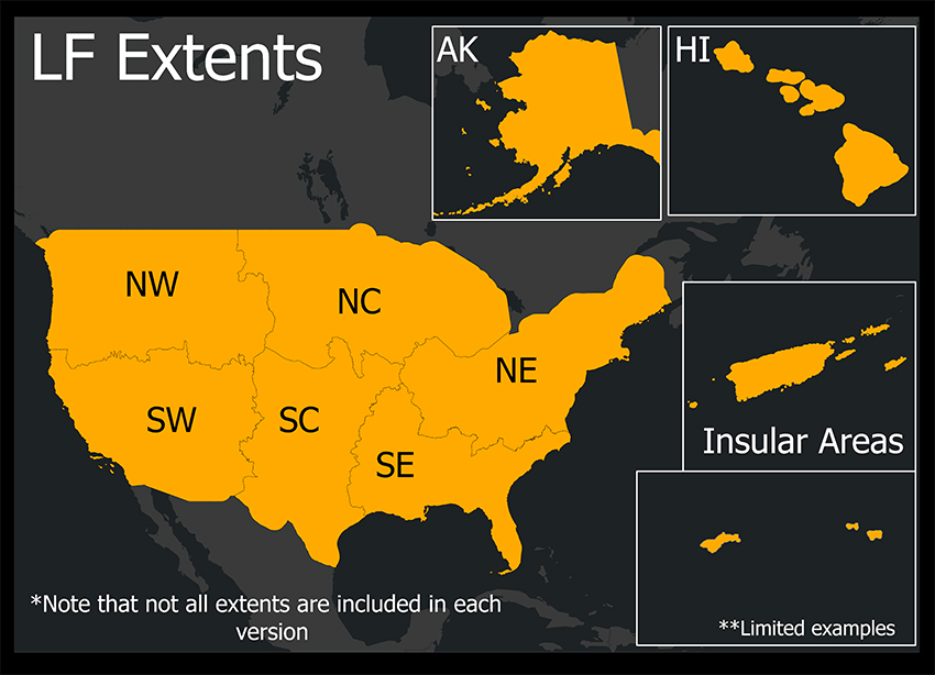
Map of the US and AK and HI in small boxes offset.

The LANDFIRE 2023 Update (LF 2023) product suite represents the final step in the ongoing goal to move towards annual updates and reduced latency. LANDFIRE'S goal has been to release an annual update every year that represents one year, specifically the previous year. Similar to the LF 2022 Update, in LF 2023, disturbances from the previous year are represented in current year products. The LF 2022 Update was the first map product suite in which disturbances from the year prior are represented in current year products. Continuing the work of the annual vegetation and fuel updates, the LF 2023 Update suite provides updated layers that add to, and account for disturbance on the landscape that has occurred through October of 2023. This means the LANDFIRE team has been able to improve production efficiencies and turn around disturbances faster than ever, providing our community of users the newest data faster.

Improvements Featured in the LF 2023 Update

  • The use of 4 seasonal composites in disturbance mapping, doubling LANDFIRE’s use of satellite imagery
  • Mapped disturbance events in the 90km buffer area surrounding the Conterminous United States (CONUS)
  • Two new types of Annual Disturbance products – Limited and Preliminary Annual Disturbance
  • New fuels calibration for the Southeast GeoArea, Colorado, and Oklahoma
  • An updated Operational Roads product for CONUS that incorporates National Land Cover Database (NLCD) 2021
  • The return of Fire Regime Group (FRG), Fire Return Interval (FRI), and Percent Fire Severity (PFS) as standalone products. The products will be applicable to LF 2016 Remap for CONUS and HI
  • Updated BPS, FRG, FRI, and PFS products for AK
  • An updated Fuel Characteristics Classification System (FCCS) product for all extents
  • Sampled GEDI canopy height data as additional training data for the tree height model

A new methodology update for Existing Vegetation Cover (EVC), Height (EVH), and Type (EVT) products within CONUS

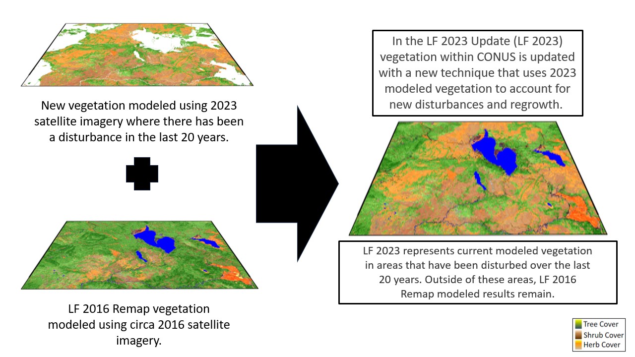
In the past LANDFIRE updates have used millions of rulesets developed from local and national experts across the United States to update mapped vegetation where disturbance has occurred. These rulesets considered the initial vegetation type, cover, and height and applied a transition rule using the disturbance type, severity, and length of time since the disturbance occurred to produce an updated EVT, EVC, and EVH products for a new version.

Since circa LF 2016 Remap (LF Remap), these rules have required to Remap inputs of EVT, EVC, and EVH. This created challenges for the update process because areas that had been disturbed in the few years prior to 2016 remained unchanged from that snapshot in time.

For LF 2023, LANDFIRE will map the lifeform, cover, and height of existing vegetation in areas that LANDFIRE has mapped as disturbed over the last twenty years (see the LANDFIRE Annual Disturbance product) using our machine learning methods. LANDFIRE focused on updating areas disturbed over the last 20 years since these are the areas that have most likely changed the most.

Layers for LF 2013 and LF 2016 data combined
LF Office Hours: New Methods Explained: Improving Vegetation Your guide to Everything LANDFIRE in 2024 2023 - 24 Missoula Fire Lab Seminar Series

NEW Products included in LF 2023

To provide sooner delivery of LANDFIRE Annual Disturbance data and to ensure a more complete record, LANDFIRE has decided to distribute more Annual Disturbance products.

What does this change mean? There are now three Annual Disturbance products released in a single version – each with a unique name and identity.

LF 2023 Update Products and Descriptions

THEMEPRODUCT NAMEABBREVIATION
DisturbanceLimited DisturbanceLDist23
Preliminary Annual DisturbancePDist23
2023 Annual DisturbanceDist23
Historical DisturbanceHDist23
Fuel DisturbanceFDist23
Historic Fire RegimeFire Regime GroupsFRG
Fire Return IntervalFRI
Percent Fire SeverityPFS
Fuel13 Anderson Fire Behavior Fuel ModelsFBFM13
40 Scott and Burgan Fire Behavior Fuel ModelsFBFM40
Forest Canopy Bulk DensityCBD
Forest Canopy Base HeightCBH
Forest Canopy CoverCC
Forest Canopy HeightCH
Canadian Forest Fire Danger Rating SystemCFFDRS
Operational RoadsRoads
Fuel Vegetation CoverFVC
Fuel Vegetation HeightFVH
Fuel Vegetation TypeFVT
Fuel Rulesets DatabaseFRDB
Fuel Characteristic Classification System FuelbedsFCCS
ReferencePublic Events GeodatabaseEventsDB
Public Exotics GeodatabaseExoticsDB
Public Model Ready Events GeodatabaseModelReadyDB
VegetationBiophysical SettingsBPS
Existing Vegetation TypeEVT
Existing Vegetation CoverEVC
Existing Vegetation HeightEVH
Succession ClassesSClass
Vegetation Condition ClassVCC
Vegetation Departure IndexVDep


LF 2023 Update Schedule

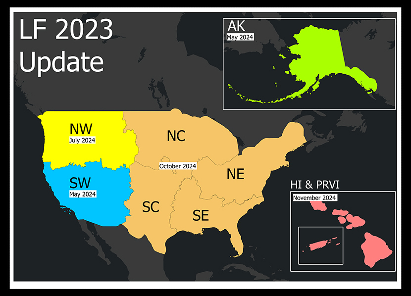
LF 2023 is being released by Conterminous United States (CONUS) GeoArea beginning in May 2024 with the SW along with Alaska (AK). Remaining GeoAreas, Hawaii (HI), and select Insular Areas (IA), Puerto Rico and the US Virgin Islands (PRVI) will be later in the year.

2023 GeoAreas

January 2024Limited LDist CONUS, AK, HI, IA
Early May 2024AK
Late May 2024CONUS (SW)
July 2024CONUS (NW)
September 2024Annual Disturbance (CONUS, AK) & Public Events GDB (all extents)
October 2024CONUS (full extent)
November 2024HI, IA (PRVI)


Delivery Schedule

Download LF 2023 Data