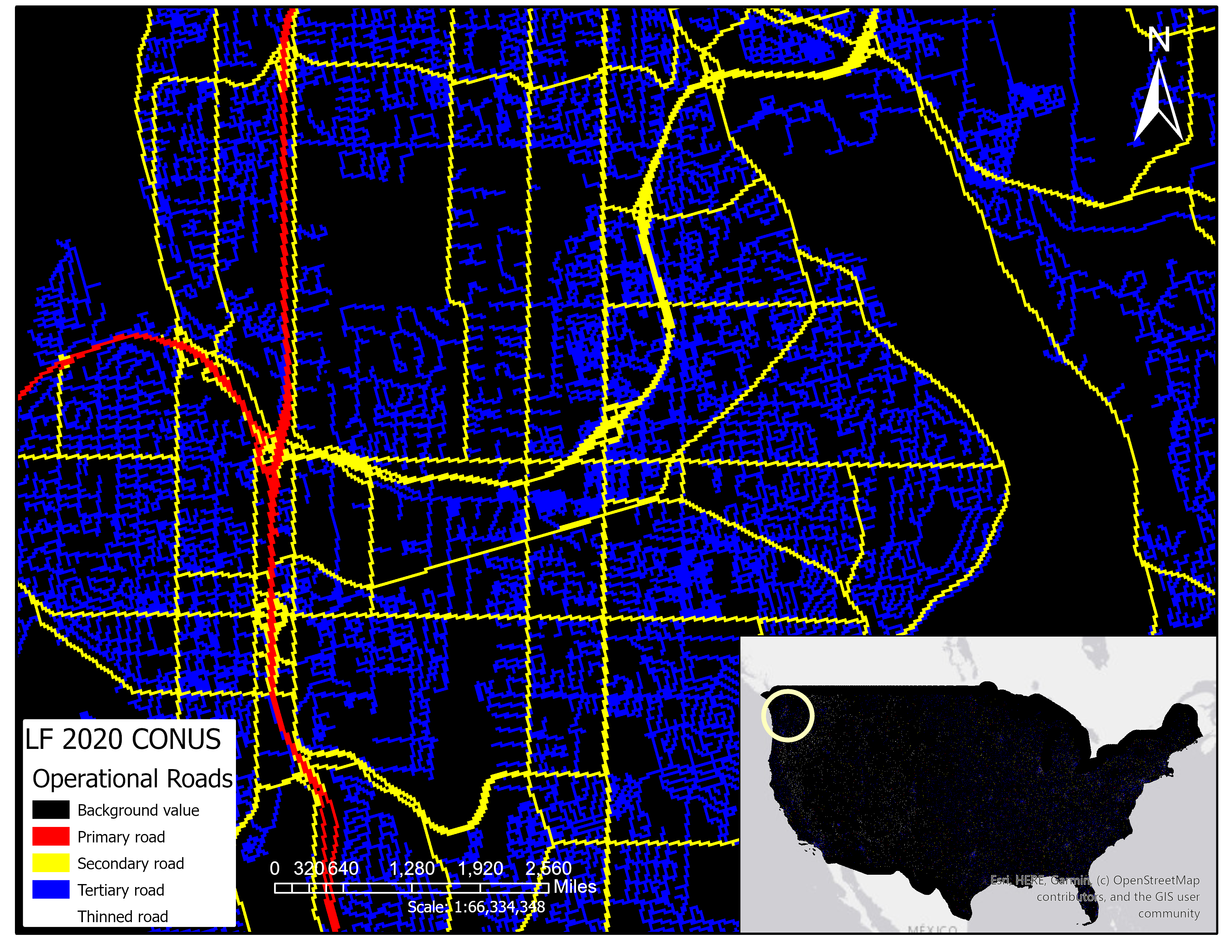
Graphic showing arrows to the cycle the BPS flowsLANDFIRE (LF) calls historic (pre-European settlement) ecosystems "Biophysical Settings," or BpS. To better understand how BpS functioned across the United States, LF worked with hundreds of experts to develop descriptions and models. The results are combined into "sets" or bundles that are available to anyone for free online.

The What and the How of BpS Models

LF used an expert-based development process to create state-and-transition models that describe pre-settlement ecosystem structure and function for every Ecological System present in the current LF BpS spatial dataset. Each ecosystem, which LF calls a Biophysical Setting (BpS), has a description document and a quantitative state-and-transition model including succession/growth and disturbance that can be viewed and manipulated in the free modeling platform SyncroSim.

LF used the BpS models to estimate reference conditions (sometimes referred to as "Natural Range of Variability" or NRV) for each BpS, which are then used to help evaluate ecosystem health through a departure metric called Vegetation Departure. The document "Using the LF Biophysical Settings Model Descriptions" examines major elements of the BpS descriptions and their uses. In addition, expert-developed models and descriptions are the source of LF's historic fire regime information.

8 column table with BpS codesCOLLABORATION BETWEEN LF + EXPERTS = MODELS
In 2015, LF began a multi-year project to review and improve the BpS data. The updated BpS model and description suite is now available for download below.

Vegetation dynamics models: a comprehensive set for natural resource assessment and planning in the United States
This article describes the ongoing development of a comprehensive set of vegetation reference conditions based on over 900 quantitative vegetation dynamic models and accompanying description documents for terrestrial ecosystems in the USA.


Supporting Information

Online resources for modelers include ApexRMS (ST-Sim developers), ST-Sim download, Forum and SyncroSim (ST-Sim) Online Documentation

How others use BpS Models

A variety of applications of BpS models have been described in project reports, meeting presentations, posters and journal articles. Examples include:


Download BpS Models and Descriptions

LF Biophysical Settings (BpS) products and format delivery include three options:
  1. Compiled databases in the Lower 48 States and Hawaii OR Alaska extents using links in the table
  2. BpS model information

    Biophysical Settings Models, Descriptions and Related Information

    • State-and-Transition Models: quantitative models of pre-European settlement ecosystem dynamics
    • BpS Descriptions: Full textual descriptions of each BpS, including model parameters and succession class rules
    • Reference Conditions: estimates of the percent of each succession class on the landscape prior to European settlement for each Ecological System
    • Succession Class Rules: Combinations of vegetation type, vegetation cover, vegetation height, leaf-form and life-form that are used by LF to map the current extent of succession classes
    • Metadata: FGDC compliant metadata for the BpS models and descriptions
  3. Spatial data - learn more

Unsure of which model you need? Use the searchable BpS website to locate and download specific BpS models and descriptions.


Product Description

LANDFIRE's (LF) Environmental Site Potential (ESP) represents the vegetation that could be supported at a given site based on the biophysical environment.

Map units are based on NatureServe's Ecological Systems classification and represent the natural plant communities that may have been present during pre-Eurpopean colonization. ESP map units represent the natural plant communities that would become established at late or climax stages of successional development in the absence of disturbance. They reflect the current climate and physical environment, as well as the competitive potential of native plant species. The ESP concept is similar to that used in classifications of potential vegetation, including habitat types and plant associations.

In early versions of LF, ESP was used to inform the existing vegetation and fuel mapping processes.

This product was not developed after LF 2014.


Environmental Site Potential Resources

Product Description

LANDFIRE's (LF) Biophysical Settings (BPS) is a modeled representation of the vegetation system that may have been dominant on the landscape prior to Euro-American settlement and is based on both the current biophysical environment and an approximation of modeled past disturbance regimes. LF uses BPS to depict reference conditions of vegetation across landscapes. Environmental Site Potential (ESP) reflects the climate and soil potential of the site, and BPS modifies that with typical disturbance for the region.

Map units are based on NatureServe's Ecological Systems classification and represent the natural plant communities that may have been present during the reference period. Each BPS map unit is matched with a model of vegetation succession. The actual time period for this data set is a composite of both the modeled context provided by the fire regime and vegetation dynamics models and the more recent field and geospatial inputs used to create it.

LF 2014 and earlier versions: BPS is unchanged from LF National's BPS except for updates made to water, barren, and snow classes (additions or removal), so that non-vegetated cover types within the BPS product matches LF existing vegetation and fuel products.

LF 2016 Remap and beyond: For the release of LF 2016 Remap, the below suite of Historic Fire Regime products were nested within the BPS product as attributes. Then, in 2024, Historic Fire Regime products became stand-alone products once again. These products can now be found in both places, as attributes of BPS and as their own products.

  • Fire Return Interval (FRI)
  • Percent Fire Severity (PFS)
  • Fire Regime Groups (FRG)

LF 2016 Remap and beyond includes a 90-kilometer buffer along the 1,500 miles of the eastern and southern borders AK shares with Canada. Then with the LF 2020 update, and future updates, for the Conterminous United States (CONUS) a 90-kilometer buffer into Mexico is also included.


Image showing colors of BPS in the upper north west corner of the US.

Related Product: The Succession Class (SClass) product characterizes current vegetation conditions with the composition, cover, and height ranges of the successional states that occur within each Biophysical Settings (BPS).


Biophysical Settings Resources

Product Description

Image showing colors for EVT-NVC in the upper north west corner of the US.LANDFIRE's (LF) Existing Vegetation Type National Vegetation Classification (EVT-NVC), an existing vegetation layer created with a new mapping process and delivered as a separate spatial data layer for the first time with LF 2016 Remap, represents the current distribution of vegetation groups within the U.S. National Vegetation Classification circa 2016. These groups are defined as combinations of relatively narrow sets of diagnostic plant species, including dominants and co-dominants, broadly similar composition, and diagnostic growth forms. LF Remap used U.S. EVT-NVC 2.0 to map LF EVT-NVC.

The LF EVT-NVC product also includes ruderal or semi-natural vegetation types. The LF Ruderal EVT-NVC Groups Descriptions for CONUS provides descriptions for each ruderal EVT-NVC Group including species, distribution, and classification information.

EVT-NVC groups were initially mapped using decision tree models informed by field reference data, Landsat imagery, elevation/topographic, and biophysical gradient inputs.

  • Decision tree models were developed separately for each life-form including tree, shrub, herbaceous, and sparse vegetation.
  • Disturbance products were included in LF Remap products to describe areas on the landscape that have experienced change within the previous 10-year period.
  • LF EVT-NVC was reconciled through QA/QC measures to ensure lifeform is synchronized with both Existing Vegetation Cover and Existing Vegetation Height.
  • When modeled results were poor for modeled EVT-NVC classes, rectification and/or cross-walking from existing ancillary datasets or Ecological Systems was performed to improve the quality of the product.

LF 2016 Remap for Alaska (AK) includes a 90-kilometer buffer along the 1,500 miles of the eastern and southern borders AK shares with Canada.

LF Remap Auto-Keys: Learn about the redesign of the Auto-Keys process, which is used to determine existing vegetation type classification based on plot data in the LFRDB — Developing Auto-Keys for LF Vegetation Mapping: 2014-2015 CONUS Project Report.

LF uses an assessment process that compares the EVT product for a pixel with the Auto-Key EVT assignment for a sample plot contained in that pixel. EVT-NVC is part of the assessment. Agreement assessments have been developed for each LF Remap CONUS GeoArea


National Vegetation Classification Resources

Product Description

Image in the upper north west corner of the US showing different colors for EVT.This page includes a general description of the product, please consult the schedule and version pages for information specific to each release.

LANDFIRE's (LF) Existing Vegetation Type (EVT-ES) represents the current distribution of the terrestrial ecological systems classification, developed by NatureServe for the western hemisphere, through 2016. A terrestrial ecological system is defined as a group of plant community types (associations) that tend to co-occur within landscapes with similar ecological processes, substrates, and/or environmental gradients.

The LF Ecological Systems Descriptions for CONUS
     » provides descriptions for each Ecological System including species, distribution and classification information. 

Learn about the history of the Ecological Systems Classification developed by NatureServe


EVT-ES also includes ruderal or semi-natural vegetation types within the U.S. National Vegetation Classification. The LF Ruderal EVT-NVC Groups Descriptions for CONUS provides descriptions for each ruderal EVT-NVC Group including species, distribution, and classification information.

EVT-ES is mapped using decision tree models, field data, Landsat imagery, elevation, and biophysical gradient data.

  • Decision tree models are developed separately for each of the three lifeforms—tree, shrub, and herbaceous and are then used to generate lifeform specific EVT-ES layers.
  • Disturbance products are included in LF products to describe areas on the landscape that have experienced change within the previous 10-year period.

LF 2016 Remap and beyond includes a 90-kilometer buffer along the 1,500 miles of the eastern and southern borders AK shares with Canada. Then with the LF 2020 update, and future updates, for the Conterminous United States (CONUS) a 90-kilometer buffer into Mexico is also included.

For LF 2016 Remap there was a redesign of the Auto-Keys process, which is used to determine existing vegetation type classification based on plot data in the LANDFIRE Reference Database (LFRDB) — Developing Auto-Keys for LF Vegetation Mapping: 2014-2015 CONUS Project Report

LF uses an assessment process that compares the EVT-ES product for a pixel with the Auto-Key EVT-ES assignment for a sample plot contained in that pixel. Learn more about agreement assessments.

An example of how to create a map of EVT for CONUS utilizing sub-class bins


Existing Vegetation Type Resources

Product Description

Image showing colors for EVH in the upper north west corner of the USThis page includes a general description of the product, please consult the schedule and version pages for information specific to each release.

LANDFIRE's (LF) Existing Vegetation Height (EVH) represents the average height of the dominant vegetation for a 30-m cell.

Canopy height is generated separately for tree, shrub, and herbaceous lifeforms using training data and other geospatial layers. EVH is determined by the average height weighted by species cover and based on the Existing Vegetation Type (EVT) lifeform.

  • Decision tree models using field reference data, lidar, Landsat, and ancillary data are developed separately for each lifeform. Decision tree relationships are used to generate lifeform specific height class layers, which are merged into a single composite EVH layer.
  • Disturbance data is used to develop products for LANDFIRE Reference Database (LFRDB) plot filtering and to ensure that disturbances from recent years are included that were not visible in the source imagery.

LF 2016 Remap and beyond includes a 90-kilometer buffer along the 1,500 miles of the eastern and southern borders AK shares with Canada. Then with the LF 2020 update, and future updates, for the Conterminous United States (CONUS) a 90-kilometer buffer into Mexico is also included.

LF uses EVH in several subsequent layers, including the development of the fuel products.


Existing Vegetation Height Resources

Version Descriptions

Click on the version links below to learn more about each version of LANDFIRE.

Person standing in a fire blaze in the forest


Data Use Recommendations

This section provides resources for appropriate applications and how to use LF products.

Product Description

Image showing EVC colorations on the upper northwest corner of the U.S.This page includes a general description of the product, please consult the schedule and version pages for information specific to each release.

LANDFIRE's (LF) Existing Vegetation Cover (EVC) represents the vertically projected percent cover of the live canopy layer for a 30-m cell. 

EVC is generated separately for tree, shrub, and herbaceous cover lifeforms using training data and other geospatial layers. Percentage tree, shrub, and herbaceous canopy cover training data are generated using plot-level ground-based visual assessments and lidar observations.

  • Once the training data are developed, relationships are then established separately for each lifeform between the training data and combination of Landsat and ancillary data. Each of the derived data layers (tree, shrub, herbaceous) has a potential range from 0-100 percent which are merged into a single composite EVC layer.
  • Disturbance data is used to develop LF products for LANDFIRE Reference Database (LFRDB) plot filtering and to ensure that disturbances from recent years are included that were not visible in the source imagery.

LF 2016 Remap and beyond includes a 90-kilometer buffer along the 1,500 miles of the eastern and southern borders AK shares with Canada. Then with the LF 2020 update, and future updates, for the Conterminous United States (CONUS) a 90-kilometer buffer into Mexico is also included.

LF uses EVC in several subsequent layers, including the development of the fuel layers.


Existing Vegetation Cover Resources


Plant in a dry ground.LANDFIRE (LF) existing vegetation layers describe the following elements: Existing Vegetation Type (EVT), Existing Vegetation Canopy Cover (EVC), and Existing Vegetation Height (EVH). These layers are created using predictive landscape models based on extensive field-referenced data, satellite imagery and biophysical gradient layers using classification and regression trees. LF potential vegetation layers describe the following elements: Biophysical Settings (BPS) and Environmental Site Potential (ESP). These layers are created using predictive landscape models based on extensive field-referenced data and biophysical gradient layers using classification and regression trees.