


 Latest News
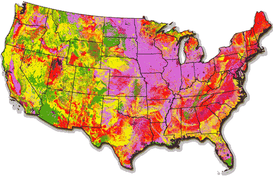 Fire Regime Condition Class (FRCC) was an interagency tool used to determine the degree of ecological departure from historical, or reference condition, vegetation, fuels, and disturbance regimes. FRCC assessments helped guide management objectives and prioritize treatments.
FRCC Background
Developed in 2002, FRCC provided an assessment tool to understand historical reference landscapes, current conditions, and ecological departure. Relationships between natural disturbances and resulting vegetation patterns were used to inform current conditions and management opportunities.
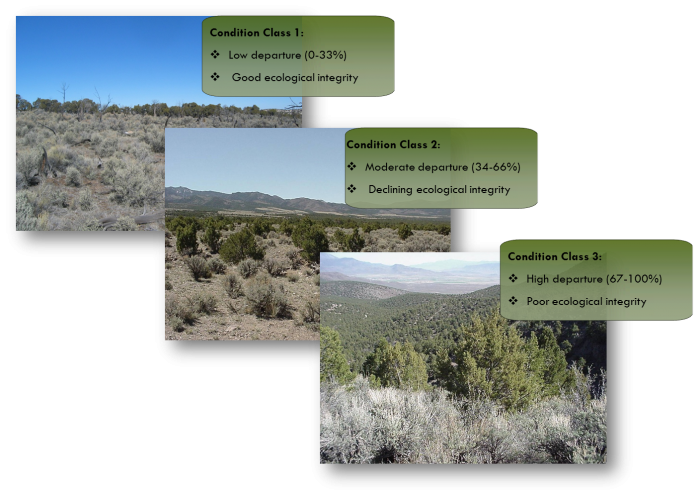
What are Reference Conditions?
Reference conditions describe historical seral stages, vegetation patterns, and fire regimes. FRCC used reference conditions to define pre-settlement landscapes. These became the baseline against which current conditions were compared.
Why Fire Regimes?
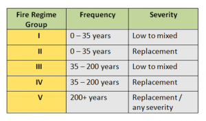
Fire regimes are commonly used to describe fire’s role in wildland ecosystems. Characteristics include fire frequency, severity, extent, pattern, seasonality, and variability. FRCC used historical fire frequency and severity traits to assign each vegetation type to a fire regime group:
Which Plant Classification was used?
FRCC used biophysical settings (BpS) to describe disturbance-maintained vegetation communities. The BpS unit is a mid-scale refinement of Potential Natural Vegetation Groups (Kuchler 1964). Each BpS has a unique model and description document which summarizes the fire regime, distribution, and ecology of the type. Select a BpS model for your area
FRCC: How it Works
FRCC assessments determine how similar a landscape's fire regime is to its natural or historical state. There are three FRCC categories:
FRCC 1 - contain vegetation patterns and disturbance regimes characteristic of the natural regime
FRCC 2 landscapes are those that are moderately departed from the natural regime
FRCC 3 landscapes reflect vegetation and disturbances that are uncharacteristic of the natural regime.
FRCC 1 has key ecosystem components intact, such as large old trees and soil characteristics that would naturally be found on that site. FRCC 2 indicates the land is very different from its natural regime in terms of its vegetation or disturbances or both. FRCC 3 has lost key ecosystem components; an example could be the loss of characteristic large trees due to uncharacteristic wildfires that occurred in uncharacteristic fuels.
FRCC Application
FRCC has been applied at various scales. Nationally, FRCC was used to summarize land health trends, in monitoring treatment accomplishments, and as a performance measure for fuels management programs. Regionally, FRCC has been used in conservation planning related to wide-ranging species. Locally, FRCC was used in land use and fire management plans and environmental assessments. FRCC has also been used to design projects and as a required element of reporting.
FRCC methods and resources are explained further in the Interagency FRCC Guidebook.
Kuchler, A.W. 1964. Potential natural vegetation of the conterminous United States (manual and map). Special Publ. 36, 1965 rev. New York: American Geographical Society. 116 p.
Additional FRCC information is available upon request by contacting the LF Help Desk.


