


 Latest News
LANDFIRE (LF) 2016 Remap is the most comprehensive mapping effort in LF's history. This years-long effort included updating the base maps across the original data product suite to create LF's second base map product suite consisting of 28 vegetation and fuels layers. LF Remap products reflect circa 2016 ground conditions.
The initial base map (LF National) product suite was developed using Landsat imagery circa 2001. The product suite was updated regularly using vegetation and fuel transition rulesets to more accurately represent current conditions and account for landscape disturbances (LF 2008, 2010, 2012, and 2014). However, with a base map more than 15 years old, LF decided it was time to remap the landscape.
Designed to produce vegetation and fuels data that inform wildland fire and ecological decision systems, LF Remap processes followed consistent methodologies to incorporate current satellite imagery, contemporary data sources, and the latest software and hardware technologies. The resulting LF Remap data products offer significant improvements to all previous LF versions.
Advances in image compositing, satellite image tiling algorithms, plus faster computing hardware ensures LF vegetation and fuels products remain relevant. To achieve this, LF Remap leveraged the Landsat archive, lidar data, and over 1 million ground control plots from a variety of partners and collaborators compiled into the LF Reference Database (LFRDB), to characterize landscape characteristics for more than 9 billion 30-meter pixels across CONUS. Learn more about contributing plot data for future mapping efforts.
Starting with LF 2016 Remap for Alaska (AK), LF products will include a 90-kilometer buffer along the borders of neighboring countries. For LF Remap AK that includes 1,538 miles of border with Canada.
All LF data product categories have been refined as part of the remap effort: Reference • Disturbance • Vegetation • Fuel • Fire Regimes • Topographic
'NEW' - Capable Fuels - LF Remap enhancements to fuels products in disturbed areas
A discrepancy in Time Since Disturbance (TSD) 1 (0-1 years) for surface and canopy fuels in disturbed areas existed in previous versions of LF Update products. TSD was not truly representative of the release date. For example, fuel layers created from 2012 disturbance data were released in 2014, meaning TSD lagged two years behind and users had to adjust accordingly. This issue has been corrected in LF Remap fuel products (Fuel Disturbance, Canopy Height, Canopy Cover/Base Density/Base Height, Fire Behavior Fuel Model 13 and 40, Fuel Vegetation Cover/Type/Height, and Fuel Characteristic Classification System) by synchronizing TSDs for surface and canopy fuels in disturbed areas.
What this means is LF Remap fuels products in disturbed areas have been revised to expected 2019 or 2020 vegetation conditions for disturbances that occurred between 2009-2016 or 2010-2016, respectively, making the fuels products 2019 or 2020 capable.
The capable fuels functionality is able to calculate TSD assignments for disturbed areas using an "effective year." Utilizing fuel model transition rulesets, fuels within disturbed areas over the 10-yr period prior are transitioned to the capable year. Therefore, when fire behavior modelers encounter a disturbance (that occurred within the last 10 years) on their landscape, the fuels within the disturbance should reflect growth after the disturbance and up until the capable year, rather than a few years before.
This improves performance of fire behavior modeling and reduces the need for local LF users to update the vegetation and fuel conditions to represent current conditions.
As a result, LF Remap capable fuels layers better represent active and potential wildfire behavior on the current landscape.
LF Remap Resources
Vegetation dynamics models: a comprehensive set for natural resource assessment and planning in the U.S.
LF Remap Schedule
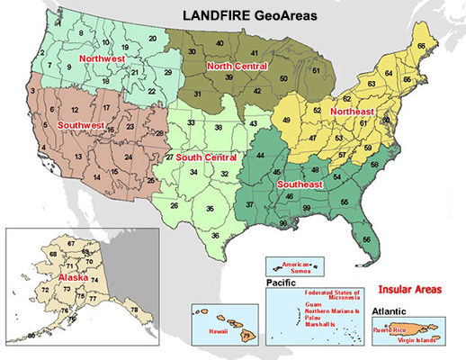
LF 2016 Remap production began in 2017 with products released by LF Geographic Areas (GeoAreas). There are six GeoAreas for the Contiguous United States (CONUS), and one each for Alaska, Hawaii, and the insular areas. Starting with the Northwest in early 2019, LF 2016 products were released through 2021.
Download Data |
|
||||||||
What to Expect — LF Remap Changes and Improvements
The LF team at the USGS Earth Resources Observation and Science (EROS) Center used the latest data and processing techniques to produce new vegetation, fuels, and fire regime base layers for the LF Remap data product suite, representing a circa 2016 ground condition.
LF Remap improvements include:
LF Remap Documentation
LANDFIRE Remap Prototype Mapping Effort: Developing a New Framework for Mapping Vegetation Classification, Change, and Structure - a narrative of the innovative methodologies in image processing and mapping used to create LF Remap LANDFIRE vegetation products
LF Remap - Utilization of Remotely Sensed Data to Classify Existing Vegetation Type and Structure to Support Strategic Planning and Tactical Response - characterizing vegetation type, cover, and height with Earth observation data enhances wildland fuel modeling.
LF Remap Summary Description (currently under revision)
Developing LF Remap by Production Unit - products are developed using a combination of legacy and new productions units.


